You are here: Home > Network List > TA - USArray Transportable Network (new EarthScope stations) Stations List
> Station I59A Olmsteadville, NY, USA > Earthquake Result Viewer
I59A Olmsteadville, NY, USA - Earthquake Result Viewer
| Earthquake location: |
Off East Coast Of Honshu, Japan |
| Earthquake latitude/longitude: |
37.9/144.2 |
| Earthquake time(UTC): |
2014/05/02 (122) 09:15:20 GMT |
| Earthquake Depth: |
15 km |
| Earthquake Magnitude: |
5.9 MWP |
| Earthquake Catalog/Contributor: |
NEIC PDE/NEIC COMCAT |
|
| Network: |
TA USArray Transportable Network (new EarthScope stations) |
| Station: |
I59A Olmsteadville, NY, USA |
| Lat/Lon: |
43.80 N/73.87 W |
| Elevation: |
390 m |
|
| Distance: |
91.7 deg |
| Az: |
26.565 deg |
| Baz: |
330.746 deg |
| Ray Param: |
0.04157338 |
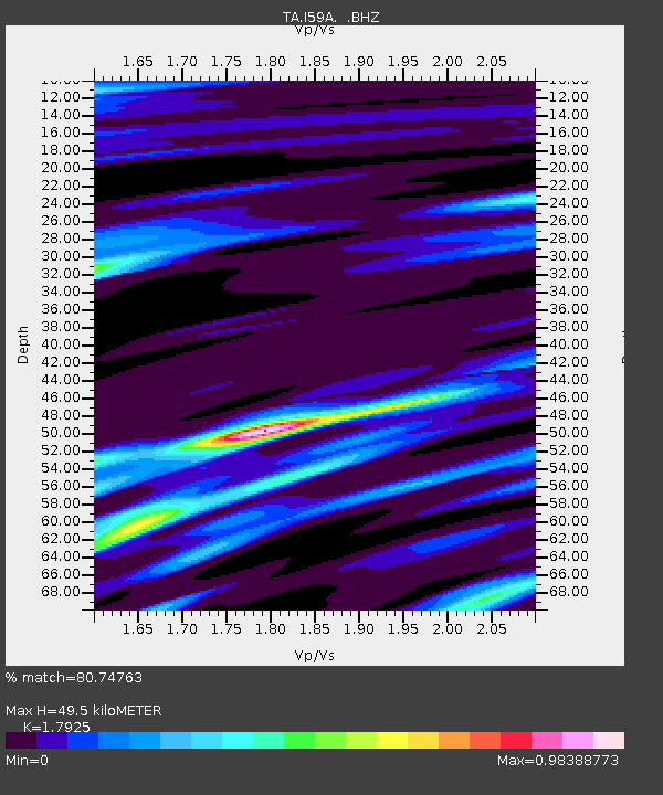
| Estimated Moho Depth: |
49.5 km |
| Estimated Crust Vp/Vs: |
1.79 |
| Assumed Crust Vp: |
6.419 km/s |
| Estimated Crust Vs: |
3.581 km/s |
| Estimated Crust Poisson's Ratio: |
0.27 |
|
| Radial Match: |
80.74763 % |
| Radial Bump: |
400 |
| Transverse Match: |
69.05747 % |
| Transverse Bump: |
400 |
| SOD ConfigId: |
626651 |
| Insert Time: |
2014-05-16 09:57:08.538 +0000 |
| GWidth: |
2.5 |
| Max Bumps: |
400 |
| Tol: |
0.001 |
|
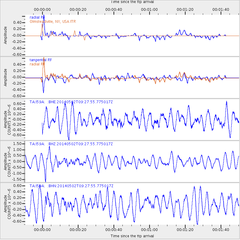
Signal To Noise
| Channel | StoN | STA | LTA |
| TA:I59A: :BHZ:20140502T09:27:55.775017Z | 1.574467 | 7.6448777E-7 | 4.855534E-7 |
| TA:I59A: :BHN:20140502T09:27:55.775017Z | 1.1044666 | 2.9841405E-7 | 2.701884E-7 |
| TA:I59A: :BHE:20140502T09:27:55.775017Z | 0.5084573 | 1.6985638E-7 | 3.340622E-7 |
| Arrivals |
| Ps | 6.2 SECOND |
| PpPs | 21 SECOND |
| PsPs/PpSs | 27 SECOND |


