You are here: Home > Network List > TA - USArray Transportable Network (new EarthScope stations) Stations List
> Station J01E Myrtle Point, OR, USA > Earthquake Result Viewer
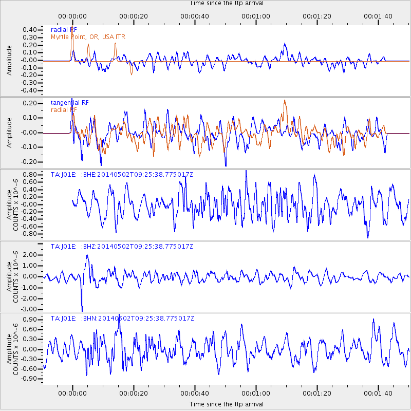
J01E Myrtle Point, OR, USA - Earthquake Result Viewer
*The percent match for this event was below the threshold and hence no stack was calculated.
| Earthquake location: |
Off East Coast Of Honshu, Japan |
| Earthquake latitude/longitude: |
37.9/144.2 |
| Earthquake time(UTC): |
2014/05/02 (122) 09:15:20 GMT |
| Earthquake Depth: |
15 km |
| Earthquake Magnitude: |
5.9 MWP |
| Earthquake Catalog/Contributor: |
NEIC PDE/NEIC COMCAT |
|
| Network: |
TA USArray Transportable Network (new EarthScope stations) |
| Station: |
J01E Myrtle Point, OR, USA |
| Lat/Lon: |
43.16 N/123.93 W |
| Elevation: |
128 m |
|
| Distance: |
66.5 deg |
| Az: |
52.877 deg |
| Baz: |
300.429 deg |
| Ray Param: |
$rayparam |
*The percent match for this event was below the threshold and hence was not used in the summary stack. |
|
| Radial Match: |
53.24318 % |
| Radial Bump: |
400 |
| Transverse Match: |
62.961384 % |
| Transverse Bump: |
400 |
| SOD ConfigId: |
626651 |
| Insert Time: |
2014-05-16 09:57:17.149 +0000 |
| GWidth: |
2.5 |
| Max Bumps: |
400 |
| Tol: |
0.001 |
|
Signal To Noise
| Channel | StoN | STA | LTA |
| TA:J01E: :BHZ:20140502T09:25:38.775017Z | 3.296094 | 1.0621425E-6 | 3.2224278E-7 |
| TA:J01E: :BHN:20140502T09:25:38.775017Z | 1.1348522 | 2.8489262E-7 | 2.510394E-7 |
| TA:J01E: :BHE:20140502T09:25:38.775017Z | 0.85915625 | 2.550112E-7 | 2.9681587E-7 |
| Arrivals |
| Ps | |
| PpPs | |
| PsPs/PpSs | |


