You are here: Home > Network List > TA - USArray Transportable Network (new EarthScope stations) Stations List
> Station L46A Eue Claire, MI, USA > Earthquake Result Viewer
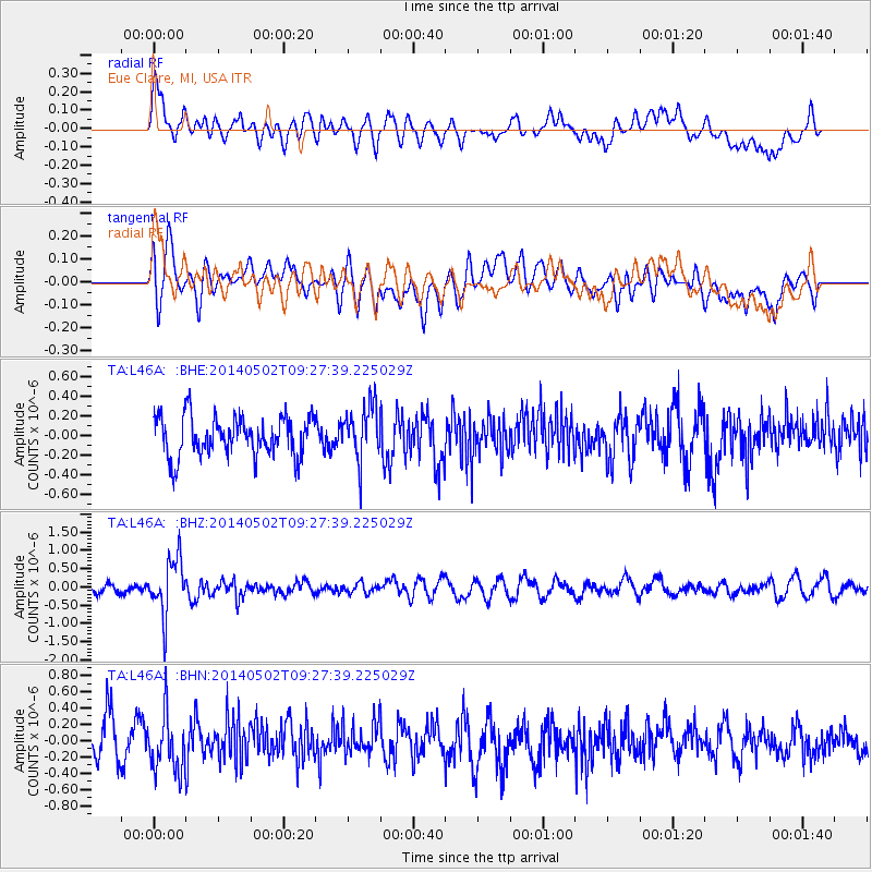
L46A Eue Claire, MI, USA - Earthquake Result Viewer
*The percent match for this event was below the threshold and hence no stack was calculated.
| Earthquake location: |
Off East Coast Of Honshu, Japan |
| Earthquake latitude/longitude: |
37.9/144.2 |
| Earthquake time(UTC): |
2014/05/02 (122) 09:15:20 GMT |
| Earthquake Depth: |
15 km |
| Earthquake Magnitude: |
5.9 MWP |
| Earthquake Catalog/Contributor: |
NEIC PDE/NEIC COMCAT |
|
| Network: |
TA USArray Transportable Network (new EarthScope stations) |
| Station: |
L46A Eue Claire, MI, USA |
| Lat/Lon: |
42.01 N/86.30 W |
| Elevation: |
223 m |
|
| Distance: |
88.1 deg |
| Az: |
35.148 deg |
| Baz: |
322.318 deg |
| Ray Param: |
$rayparam |
*The percent match for this event was below the threshold and hence was not used in the summary stack. |
|
| Radial Match: |
50.271935 % |
| Radial Bump: |
400 |
| Transverse Match: |
48.46136 % |
| Transverse Bump: |
400 |
| SOD ConfigId: |
626651 |
| Insert Time: |
2014-05-16 09:59:01.341 +0000 |
| GWidth: |
2.5 |
| Max Bumps: |
400 |
| Tol: |
0.001 |
|
Signal To Noise
| Channel | StoN | STA | LTA |
| TA:L46A: :BHZ:20140502T09:27:39.225029Z | 3.9407494 | 7.609445E-7 | 1.9309638E-7 |
| TA:L46A: :BHN:20140502T09:27:39.225029Z | 1.2859733 | 3.3122618E-7 | 2.5756847E-7 |
| TA:L46A: :BHE:20140502T09:27:39.225029Z | 1.3847259 | 2.7960445E-7 | 2.0192044E-7 |
| Arrivals |
| Ps | |
| PpPs | |
| PsPs/PpSs | |


