You are here: Home > Network List > TA - USArray Transportable Network (new EarthScope stations) Stations List
> Station M48A Edgerton, OH, USA > Earthquake Result Viewer
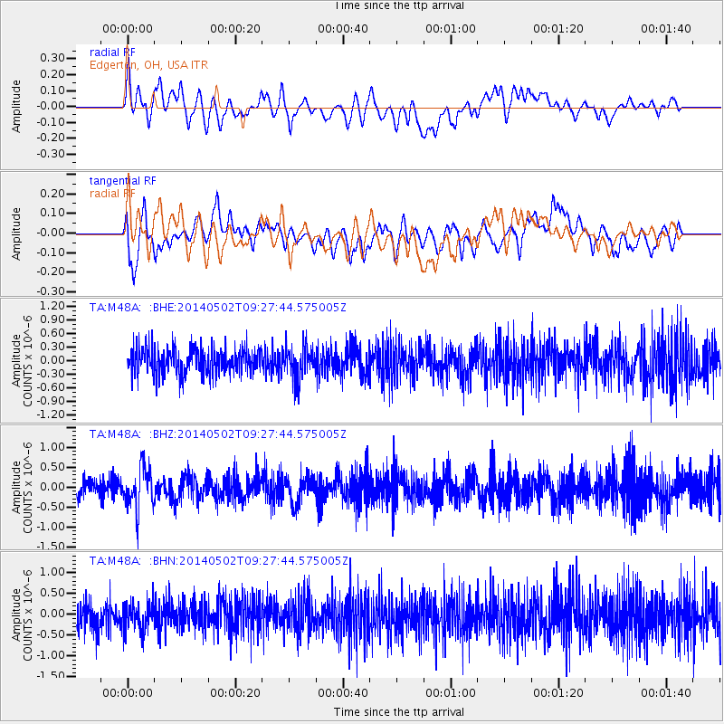
M48A Edgerton, OH, USA - Earthquake Result Viewer
*The percent match for this event was below the threshold and hence no stack was calculated.
| Earthquake location: |
Off East Coast Of Honshu, Japan |
| Earthquake latitude/longitude: |
37.9/144.2 |
| Earthquake time(UTC): |
2014/05/02 (122) 09:15:20 GMT |
| Earthquake Depth: |
15 km |
| Earthquake Magnitude: |
5.9 MWP |
| Earthquake Catalog/Contributor: |
NEIC PDE/NEIC COMCAT |
|
| Network: |
TA USArray Transportable Network (new EarthScope stations) |
| Station: |
M48A Edgerton, OH, USA |
| Lat/Lon: |
41.48 N/84.72 W |
| Elevation: |
258 m |
|
| Distance: |
89.2 deg |
| Az: |
34.526 deg |
| Baz: |
323.351 deg |
| Ray Param: |
$rayparam |
*The percent match for this event was below the threshold and hence was not used in the summary stack. |
|
| Radial Match: |
37.440804 % |
| Radial Bump: |
400 |
| Transverse Match: |
57.05618 % |
| Transverse Bump: |
400 |
| SOD ConfigId: |
626651 |
| Insert Time: |
2014-05-16 09:59:40.402 +0000 |
| GWidth: |
2.5 |
| Max Bumps: |
400 |
| Tol: |
0.001 |
|
Signal To Noise
| Channel | StoN | STA | LTA |
| TA:M48A: :BHZ:20140502T09:27:44.575005Z | 2.5899038 | 5.188685E-7 | 2.0034277E-7 |
| TA:M48A: :BHN:20140502T09:27:44.575005Z | 0.93791246 | 3.2990172E-7 | 3.517404E-7 |
| TA:M48A: :BHE:20140502T09:27:44.575005Z | 1.2787651 | 3.6054962E-7 | 2.8195143E-7 |
| Arrivals |
| Ps | |
| PpPs | |
| PsPs/PpSs | |


