You are here: Home > Network List > II - Global Seismograph Network (GSN - IRIS/IDA) Stations List
> Station PFO Pinon Flat, California, USA > Earthquake Result Viewer
PFO Pinon Flat, California, USA - Earthquake Result Viewer
| Earthquake location: |
Near Coast Of Central Chile |
| Earthquake latitude/longitude: |
-32.3/-71.3 |
| Earthquake time(UTC): |
1998/07/29 (210) 07:14:24 GMT |
| Earthquake Depth: |
51 km |
| Earthquake Magnitude: |
6.3 MB, 6.5 UNKNOWN, 6.5 ME |
| Earthquake Catalog/Contributor: |
WHDF/NEIC |
|
| Network: |
II Global Seismograph Network (GSN - IRIS/IDA) |
| Station: |
PFO Pinon Flat, California, USA |
| Lat/Lon: |
33.61 N/116.46 W |
| Elevation: |
1280 m |
|
| Distance: |
78.2 deg |
| Az: |
322.792 deg |
| Baz: |
142.152 deg |
| Ray Param: |
0.049734883 |
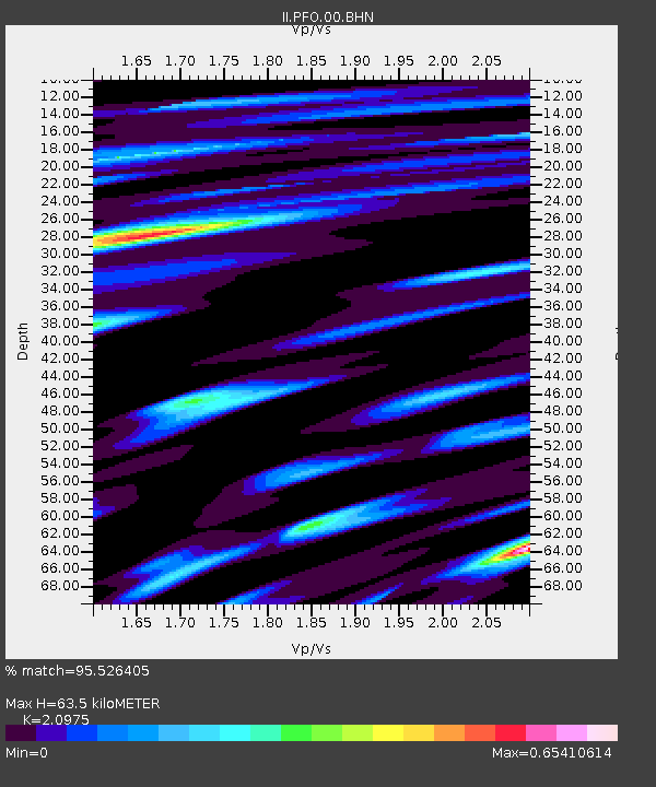
| Estimated Moho Depth: |
63.5 km |
| Estimated Crust Vp/Vs: |
2.10 |
| Assumed Crust Vp: |
6.264 km/s |
| Estimated Crust Vs: |
2.986 km/s |
| Estimated Crust Poisson's Ratio: |
0.35 |
|
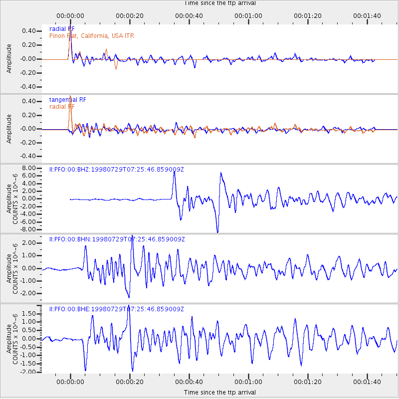
| Radial Match: |
95.526405 % |
| Radial Bump: |
384 |
| Transverse Match: |
89.38917 % |
| Transverse Bump: |
400 |
| SOD ConfigId: |
9875 |
| Insert Time: |
2010-03-01 21:40:17.290 +0000 |
| GWidth: |
2.5 |
| Max Bumps: |
400 |
| Tol: |
0.001 |
|
Signal To Noise
| Channel | StoN | STA | LTA |
| II:PFO:00:BHN:19980729T07:25:46.859009Z | 4.3045416 | 3.0531845E-7 | 7.0929374E-8 |
| II:PFO:00:BHE:19980729T07:25:46.859009Z | 3.7827518 | 3.2679654E-7 | 8.639122E-8 |
| II:PFO:00:BHZ:19980729T07:25:46.859009Z | 12.403228 | 1.3904463E-6 | 1.12103585E-7 |
| Arrivals |
| Ps | 11 SECOND |
| PpPs | 31 SECOND |
| PsPs/PpSs | 42 SECOND |


