You are here: Home > Network List > NO - Norwegian Seismic Array Network Stations List
> Station SPB3 > Earthquake Result Viewer
SPB3 - Earthquake Result Viewer
| Earthquake location: |
Rat Islands, Aleutian Islands |
| Earthquake latitude/longitude: |
52.2/178.1 |
| Earthquake time(UTC): |
2019/04/02 (092) 21:35:30 GMT |
| Earthquake Depth: |
6.5 km |
| Earthquake Magnitude: |
6.4 mww |
| Earthquake Catalog/Contributor: |
NEIC PDE/us |
|
| Network: |
NO Norwegian Seismic Array Network |
| Station: |
SPB3 |
| Lat/Lon: |
78.17 N/16.36 E |
| Elevation: |
234 m |
|
| Distance: |
49.5 deg |
| Az: |
355.114 deg |
| Baz: |
14.739 deg |
| Ray Param: |
0.0686997 |
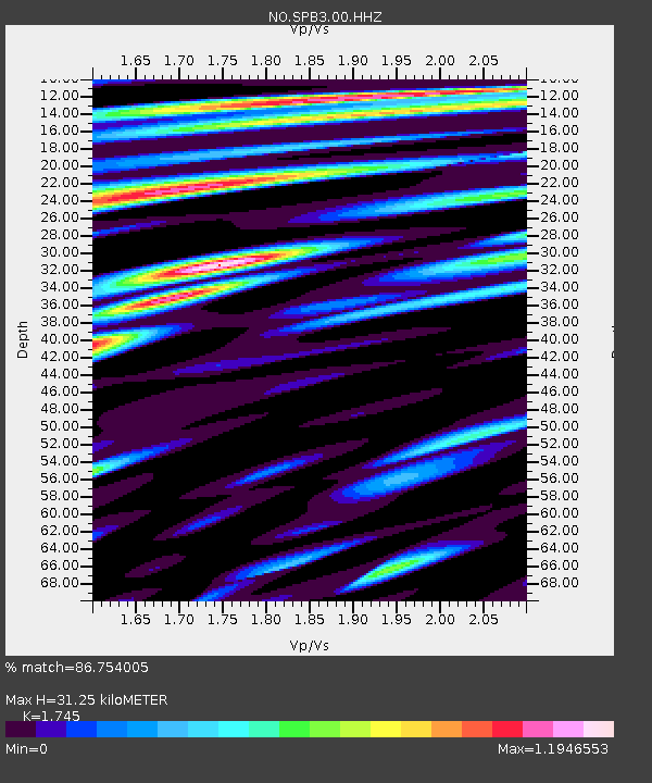
| Estimated Moho Depth: |
31.25 km |
| Estimated Crust Vp/Vs: |
1.75 |
| Assumed Crust Vp: |
6.545 km/s |
| Estimated Crust Vs: |
3.751 km/s |
| Estimated Crust Poisson's Ratio: |
0.26 |
|
| Radial Match: |
86.754005 % |
| Radial Bump: |
400 |
| Transverse Match: |
76.693474 % |
| Transverse Bump: |
400 |
| SOD ConfigId: |
7164631 |
| Insert Time: |
2019-04-16 21:59:51.958 +0000 |
| GWidth: |
2.5 |
| Max Bumps: |
400 |
| Tol: |
0.001 |
|

Signal To Noise
| Channel | StoN | STA | LTA |
| NO:SPB3:00:HHZ:20190402T21:43:49.899989Z | 4.141429 | 5.1295507E-7 | 1.2385944E-7 |
| NO:SPB3:00:HHN:20190402T21:43:49.899989Z | 3.0575457 | 2.6723012E-7 | 8.740021E-8 |
| NO:SPB3:00:HHE:20190402T21:43:49.899989Z | 1.6215528 | 1.514983E-7 | 9.342792E-8 |
| Arrivals |
| Ps | 3.8 SECOND |
| PpPs | 12 SECOND |
| PsPs/PpSs | 16 SECOND |


