You are here: Home > Network List > II - Global Seismograph Network (GSN - IRIS/IDA) Stations List
> Station PFO Pinon Flat, California, USA > Earthquake Result Viewer
PFO Pinon Flat, California, USA - Earthquake Result Viewer

| Earthquake location: |
Peru-Ecuador Border Region |
| Earthquake latitude/longitude: |
-2.3/-77.8 |
| Earthquake time(UTC): |
2007/11/16 (320) 03:13:00 GMT |
| Earthquake Depth: |
123 km |
| Earthquake Magnitude: |
6.3 MB, 6.8 MW, 6.7 MW |
| Earthquake Catalog/Contributor: |
WHDF/NEIC |
|
| Network: |
II Global Seismograph Network (GSN - IRIS/IDA) |
| Station: |
PFO Pinon Flat, California, USA |
| Lat/Lon: |
33.61 N/116.46 W |
| Elevation: |
1280 m |
|
| Distance: |
51.0 deg |
| Az: |
317.911 deg |
| Baz: |
126.626 deg |
| Ray Param: |
0.06729517 |
| Estimated Moho Depth: |
17.25 km |
| Estimated Crust Vp/Vs: |
2.10 |
| Assumed Crust Vp: |
6.264 km/s |
| Estimated Crust Vs: |
2.986 km/s |
| Estimated Crust Poisson's Ratio: |
0.35 |
|
| Radial Match: |
95.67788 % |
| Radial Bump: |
400 |
| Transverse Match: |
80.07848 % |
| Transverse Bump: |
400 |
| SOD ConfigId: |
2564 |
| Insert Time: |
2010-03-01 21:40:41.626 +0000 |
| GWidth: |
2.5 |
| Max Bumps: |
400 |
| Tol: |
0.001 |
|
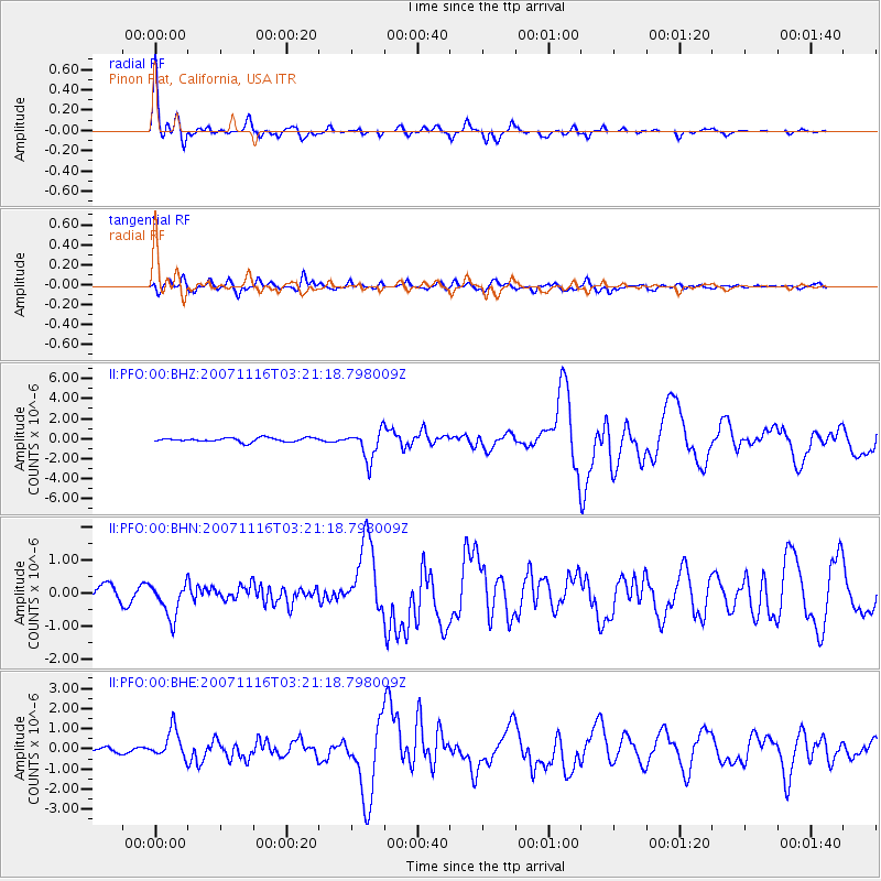
Signal To Noise
| Channel | StoN | STA | LTA |
| II:PFO:00:BHN:20071116T03:21:18.798009Z | 2.4274046 | 5.158298E-7 | 2.125026E-7 |
| II:PFO:00:BHE:20071116T03:21:18.798009Z | 6.2003846 | 7.1905987E-7 | 1.159702E-7 |
| II:PFO:00:BHZ:20071116T03:21:18.798009Z | 7.6577334 | 1.4889565E-6 | 1.9443827E-7 |
| Arrivals |
| Ps | 3.2 SECOND |
| PpPs | 8.2 SECOND |
| PsPs/PpSs | 11 SECOND |


