You are here: Home > Network List > TA - USArray Transportable Network (new EarthScope stations) Stations List
> Station T57A Hurt, VA, USA > Earthquake Result Viewer
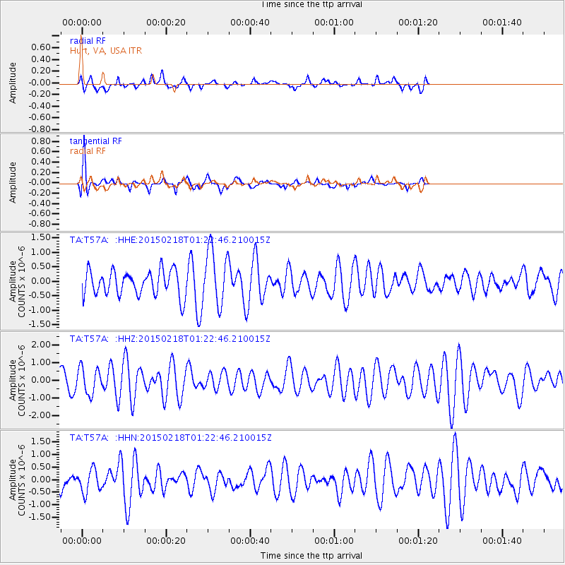
T57A Hurt, VA, USA - Earthquake Result Viewer
*The percent match for this event was below the threshold and hence no stack was calculated.
| Earthquake location: |
Northern East Pacific Rise |
| Earthquake latitude/longitude: |
8.3/-103.1 |
| Earthquake time(UTC): |
2015/02/18 (049) 01:16:17 GMT |
| Earthquake Depth: |
10 km |
| Earthquake Magnitude: |
5.5 MWC, 5.5 MWC |
| Earthquake Catalog/Contributor: |
NEIC PDE/NEIC COMCAT |
|
| Network: |
TA USArray Transportable Network (new EarthScope stations) |
| Station: |
T57A Hurt, VA, USA |
| Lat/Lon: |
37.00 N/79.25 W |
| Elevation: |
230 m |
|
| Distance: |
35.8 deg |
| Az: |
33.496 deg |
| Baz: |
223.019 deg |
| Ray Param: |
$rayparam |
*The percent match for this event was below the threshold and hence was not used in the summary stack. |
|
| Radial Match: |
54.030983 % |
| Radial Bump: |
400 |
| Transverse Match: |
76.90869 % |
| Transverse Bump: |
400 |
| SOD ConfigId: |
7019011 |
| Insert Time: |
2019-04-16 22:04:58.723 +0000 |
| GWidth: |
2.5 |
| Max Bumps: |
400 |
| Tol: |
0.001 |
|
Signal To Noise
| Channel | StoN | STA | LTA |
| TA:T57A: :HHZ:20150218T01:22:46.210015Z | 0.8492259 | 7.460812E-7 | 8.7854266E-7 |
| TA:T57A: :HHN:20150218T01:22:46.210015Z | 0.8110137 | 4.726811E-7 | 5.828275E-7 |
| TA:T57A: :HHE:20150218T01:22:46.210015Z | 2.3078654 | 9.884989E-7 | 4.2831738E-7 |
| Arrivals |
| Ps | |
| PpPs | |
| PsPs/PpSs | |


