You are here: Home > Network List > II - Global Seismograph Network (GSN - IRIS/IDA) Stations List
> Station PFO Pinon Flat, California, USA > Earthquake Result Viewer
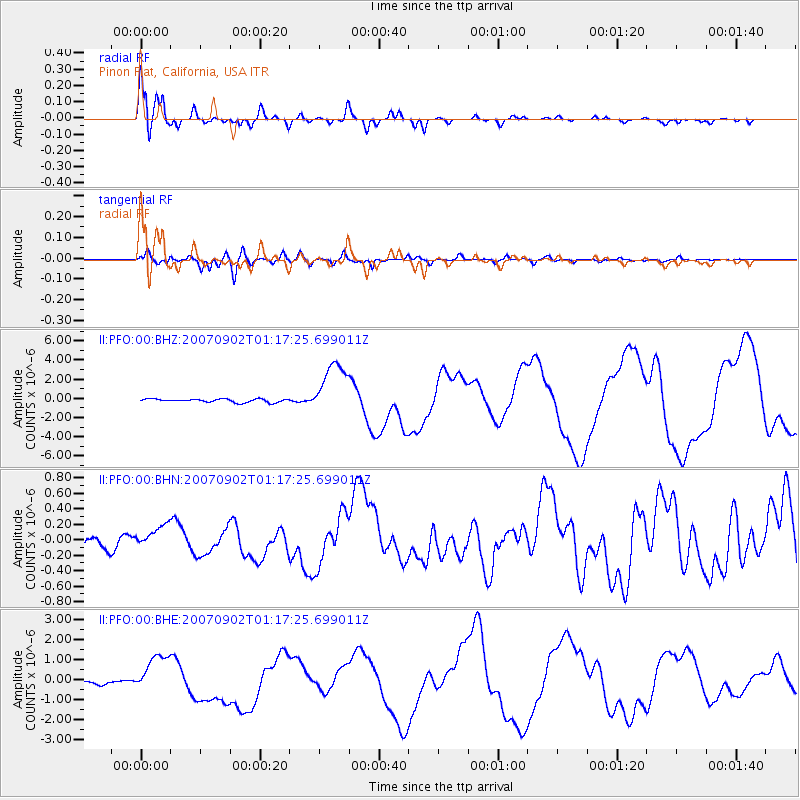
PFO Pinon Flat, California, USA - Earthquake Result Viewer

| Earthquake location: |
Santa Cruz Islands |
| Earthquake latitude/longitude: |
-11.6/165.8 |
| Earthquake time(UTC): |
2007/09/02 (245) 01:05:18 GMT |
| Earthquake Depth: |
35 km |
| Earthquake Magnitude: |
5.9 MB, 7.3 MS, 7.2 MW, 6.9 ME |
| Earthquake Catalog/Contributor: |
WHDF/NEIC |
|
| Network: |
II Global Seismograph Network (GSN - IRIS/IDA) |
| Station: |
PFO Pinon Flat, California, USA |
| Lat/Lon: |
33.61 N/116.46 W |
| Elevation: |
1280 m |
|
| Distance: |
86.4 deg |
| Az: |
54.81 deg |
| Baz: |
253.64 deg |
| Ray Param: |
0.044036407 |
| Estimated Moho Depth: |
20.25 km |
| Estimated Crust Vp/Vs: |
1.83 |
| Assumed Crust Vp: |
6.264 km/s |
| Estimated Crust Vs: |
3.427 km/s |
| Estimated Crust Poisson's Ratio: |
0.29 |
|
| Radial Match: |
97.936775 % |
| Radial Bump: |
342 |
| Transverse Match: |
91.50231 % |
| Transverse Bump: |
400 |
| SOD ConfigId: |
2564 |
| Insert Time: |
2010-03-01 21:41:11.436 +0000 |
| GWidth: |
2.5 |
| Max Bumps: |
400 |
| Tol: |
0.001 |
|
Signal To Noise
| Channel | StoN | STA | LTA |
| II:PFO:00:BHN:20070902T01:17:25.699011Z | 1.2743267 | 1.5256211E-7 | 1.1971979E-7 |
| II:PFO:00:BHE:20070902T01:17:25.699011Z | 12.101011 | 1.0043332E-6 | 8.299581E-8 |
| II:PFO:00:BHZ:20070902T01:17:25.699011Z | 16.47718 | 2.8550287E-6 | 1.7327167E-7 |
| Arrivals |
| Ps | 2.7 SECOND |
| PpPs | 8.9 SECOND |
| PsPs/PpSs | 12 SECOND |


