You are here: Home > Network List > TA - USArray Transportable Network (new EarthScope stations) Stations List
> Station W39A Magazine, AR, USA > Earthquake Result Viewer
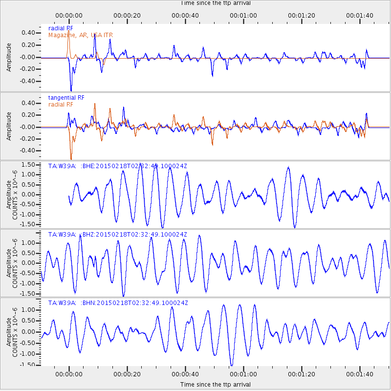
W39A Magazine, AR, USA - Earthquake Result Viewer
*The percent match for this event was below the threshold and hence no stack was calculated.
| Earthquake location: |
Ascension Island Region |
| Earthquake latitude/longitude: |
-7.7/-13.4 |
| Earthquake time(UTC): |
2015/02/18 (049) 02:20:37 GMT |
| Earthquake Depth: |
10 km |
| Earthquake Magnitude: |
5.2 MW |
| Earthquake Catalog/Contributor: |
ISC/ISC |
|
| Network: |
TA USArray Transportable Network (new EarthScope stations) |
| Station: |
W39A Magazine, AR, USA |
| Lat/Lon: |
35.20 N/93.78 W |
| Elevation: |
162 m |
|
| Distance: |
86.5 deg |
| Az: |
306.016 deg |
| Baz: |
101.79 deg |
| Ray Param: |
$rayparam |
*The percent match for this event was below the threshold and hence was not used in the summary stack. |
|
| Radial Match: |
47.981407 % |
| Radial Bump: |
320 |
| Transverse Match: |
59.30554 % |
| Transverse Bump: |
400 |
| SOD ConfigId: |
7019011 |
| Insert Time: |
2019-04-16 22:12:31.554 +0000 |
| GWidth: |
2.5 |
| Max Bumps: |
400 |
| Tol: |
0.001 |
|
Signal To Noise
| Channel | StoN | STA | LTA |
| TA:W39A: :BHZ:20150218T02:32:49.100024Z | 1.8709401 | 9.262097E-7 | 4.950504E-7 |
| TA:W39A: :BHN:20150218T02:32:49.100024Z | 2.6968358 | 6.5094684E-7 | 2.4137432E-7 |
| TA:W39A: :BHE:20150218T02:32:49.100024Z | 1.72143 | 1.1448153E-6 | 6.650375E-7 |
| Arrivals |
| Ps | |
| PpPs | |
| PsPs/PpSs | |


