You are here: Home > Network List > TA - USArray Transportable Network (new EarthScope stations) Stations List
> Station Z41A Richland Creek Farm, El Dorado, AR, USA > Earthquake Result Viewer
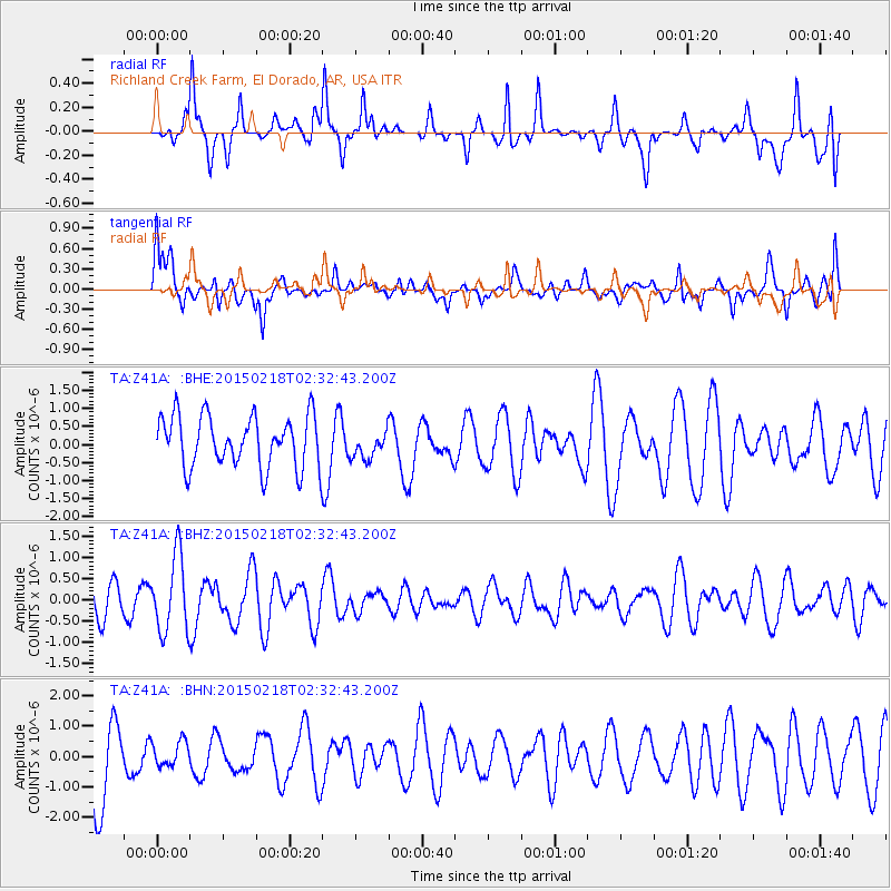
Z41A Richland Creek Farm, El Dorado, AR, USA - Earthquake Result Viewer
*The percent match for this event was below the threshold and hence no stack was calculated.
| Earthquake location: |
Ascension Island Region |
| Earthquake latitude/longitude: |
-7.7/-13.4 |
| Earthquake time(UTC): |
2015/02/18 (049) 02:20:37 GMT |
| Earthquake Depth: |
10 km |
| Earthquake Magnitude: |
5.2 MW |
| Earthquake Catalog/Contributor: |
ISC/ISC |
|
| Network: |
TA USArray Transportable Network (new EarthScope stations) |
| Station: |
Z41A Richland Creek Farm, El Dorado, AR, USA |
| Lat/Lon: |
33.26 N/92.80 W |
| Elevation: |
62 m |
|
| Distance: |
85.4 deg |
| Az: |
304.289 deg |
| Baz: |
102.217 deg |
| Ray Param: |
$rayparam |
*The percent match for this event was below the threshold and hence was not used in the summary stack. |
|
| Radial Match: |
65.08999 % |
| Radial Bump: |
400 |
| Transverse Match: |
59.414196 % |
| Transverse Bump: |
400 |
| SOD ConfigId: |
7019011 |
| Insert Time: |
2019-04-16 22:12:35.534 +0000 |
| GWidth: |
2.5 |
| Max Bumps: |
400 |
| Tol: |
0.001 |
|
Signal To Noise
| Channel | StoN | STA | LTA |
| TA:Z41A: :BHZ:20150218T02:32:43.200Z | 2.7929184 | 8.8410144E-7 | 3.165511E-7 |
| TA:Z41A: :BHN:20150218T02:32:43.200Z | 0.3154181 | 4.070054E-7 | 1.2903679E-6 |
| TA:Z41A: :BHE:20150218T02:32:43.200Z | 0.54284006 | 3.8577133E-7 | 7.1065375E-7 |
| Arrivals |
| Ps | |
| PpPs | |
| PsPs/PpSs | |


