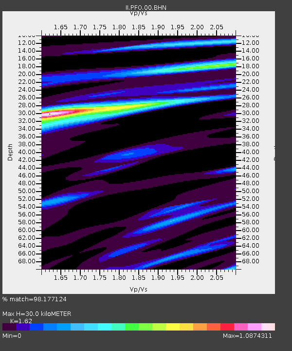
PFO Pinon Flat, California, USA - Earthquake Result Viewer

Earthquake location: Near West Coast Of Honshu, Japan
Earthquake latitude/longitude: 37.5/138.4
Earthquake time(UTC): 2007/07/16 (197) 01:13:22 GMT
Earthquake Depth: 12 km
Earthquake Magnitude: 6.5 MB, 6.4 MS, 6.6 MW, 6.5 MW
Earthquake Catalog/Contributor: WHDF/NEIC
Network: II Global Seismograph Network (GSN - IRIS/IDA)
Station: PFO Pinon Flat, California, USA
Lat/Lon: 33.61 N/116.46 W
Elevation: 1280 m
Distance: 80.7 deg
Az: 54.729 deg
Baz: 308.948 deg
Ray Param: 0.048089173
Estimated Moho Depth: 30.0 km
Estimated Crust Vp/Vs: 1.62
Assumed Crust Vp: 6.264 km/s
Estimated Crust Vs: 3.866 km/s
Estimated Crust Poisson's Ratio: 0.19
Radial Match: 98.177124 %
Radial Bump: 255
Transverse Match: 94.74005 %
Transverse Bump: 400
SOD ConfigId: 2564
Insert Time: 2010-03-01 21:41:34.305 +0000
GWidth: 2.5
Max Bumps: 400
Tol: 0.001

Signal To Noise

ChannelStoNSTALTA
II:PFO:00:BHN:20070716T01:25:03.849004Z17.7264486.971403E-73.932769E-8
II:PFO:00:BHE:20070716T01:25:03.849004Z5.82972575.915274E-71.0146745E-7
II:PFO:00:BHZ:20070716T01:25:03.849004Z22.9819342.3117395E-61.0058943E-7
Arrivals
Ps3.1 SECOND
PpPs12 SECOND
PsPs/PpSs15 SECOND