You are here: Home > Network List > TA - USArray Transportable Network (new EarthScope stations) Stations List
> Station L46A Eue Claire, MI, USA > Earthquake Result Viewer
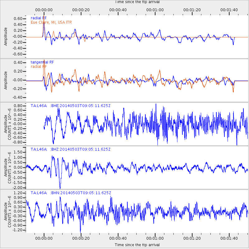
L46A Eue Claire, MI, USA - Earthquake Result Viewer
*The percent match for this event was below the threshold and hence no stack was calculated.
| Earthquake location: |
Northern Alaska |
| Earthquake latitude/longitude: |
67.6/-162.2 |
| Earthquake time(UTC): |
2014/05/03 (123) 08:57:12 GMT |
| Earthquake Depth: |
0.9 km |
| Earthquake Magnitude: |
5.5 MB |
| Earthquake Catalog/Contributor: |
NEIC PDE/NEIC COMCAT |
|
| Network: |
TA USArray Transportable Network (new EarthScope stations) |
| Station: |
L46A Eue Claire, MI, USA |
| Lat/Lon: |
42.01 N/86.30 W |
| Elevation: |
223 m |
|
| Distance: |
46.7 deg |
| Az: |
83.086 deg |
| Baz: |
329.343 deg |
| Ray Param: |
$rayparam |
*The percent match for this event was below the threshold and hence was not used in the summary stack. |
|
| Radial Match: |
59.365986 % |
| Radial Bump: |
400 |
| Transverse Match: |
50.116547 % |
| Transverse Bump: |
400 |
| SOD ConfigId: |
626651 |
| Insert Time: |
2014-05-17 09:42:33.439 +0000 |
| GWidth: |
2.5 |
| Max Bumps: |
400 |
| Tol: |
0.001 |
|
Signal To Noise
| Channel | StoN | STA | LTA |
| TA:L46A: :BHZ:20140503T09:05:11.625Z | 2.055377 | 4.547568E-7 | 2.2125225E-7 |
| TA:L46A: :BHN:20140503T09:05:11.625Z | 1.1225642 | 3.2908625E-7 | 2.9315586E-7 |
| TA:L46A: :BHE:20140503T09:05:11.625Z | 0.68694997 | 2.2081636E-7 | 3.214446E-7 |
| Arrivals |
| Ps | |
| PpPs | |
| PsPs/PpSs | |


