You are here: Home > Network List > II - Global Seismograph Network (GSN - IRIS/IDA) Stations List
> Station PFO Pinon Flat, California, USA > Earthquake Result Viewer
PFO Pinon Flat, California, USA - Earthquake Result Viewer
| Earthquake location: |
Solomon Islands |
| Earthquake latitude/longitude: |
-8.5/157.0 |
| Earthquake time(UTC): |
2007/04/01 (091) 20:39:56 GMT |
| Earthquake Depth: |
10 km |
| Earthquake Magnitude: |
6.8 MB, 7.9 MS, 8.1 MW, 7.7 ME |
| Earthquake Catalog/Contributor: |
WHDF/NEIC |
|
| Network: |
II Global Seismograph Network (GSN - IRIS/IDA) |
| Station: |
PFO Pinon Flat, California, USA |
| Lat/Lon: |
33.61 N/116.46 W |
| Elevation: |
1280 m |
|
| Distance: |
91.7 deg |
| Az: |
56.444 deg |
| Baz: |
261.065 deg |
| Ray Param: |
0.04156597 |
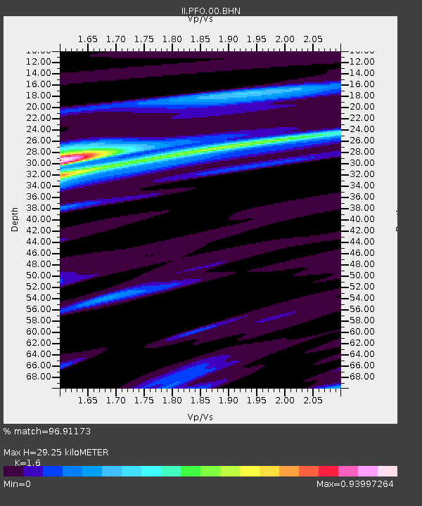
| Estimated Moho Depth: |
29.25 km |
| Estimated Crust Vp/Vs: |
1.60 |
| Assumed Crust Vp: |
6.264 km/s |
| Estimated Crust Vs: |
3.915 km/s |
| Estimated Crust Poisson's Ratio: |
0.18 |
|
| Radial Match: |
96.91173 % |
| Radial Bump: |
298 |
| Transverse Match: |
91.20694 % |
| Transverse Bump: |
400 |
| SOD ConfigId: |
2564 |
| Insert Time: |
2010-03-01 21:41:51.199 +0000 |
| GWidth: |
2.5 |
| Max Bumps: |
400 |
| Tol: |
0.001 |
|

Signal To Noise
| Channel | StoN | STA | LTA |
| II:PFO:00:BHN:20070401T20:52:32.40002Z | 0.46181914 | 6.539095E-8 | 1.4159428E-7 |
| II:PFO:00:BHE:20070401T20:52:32.40002Z | 1.8913523 | 3.0756652E-7 | 1.6261727E-7 |
| II:PFO:00:BHZ:20070401T20:52:32.40002Z | 3.7701614 | 1.0260901E-6 | 2.721608E-7 |
| Arrivals |
| Ps | 2.9 SECOND |
| PpPs | 12 SECOND |
| PsPs/PpSs | 15 SECOND |


