You are here: Home > Network List > TA - USArray Transportable Network (new EarthScope stations) Stations List
> Station U59A Littleton, NC, USA > Earthquake Result Viewer
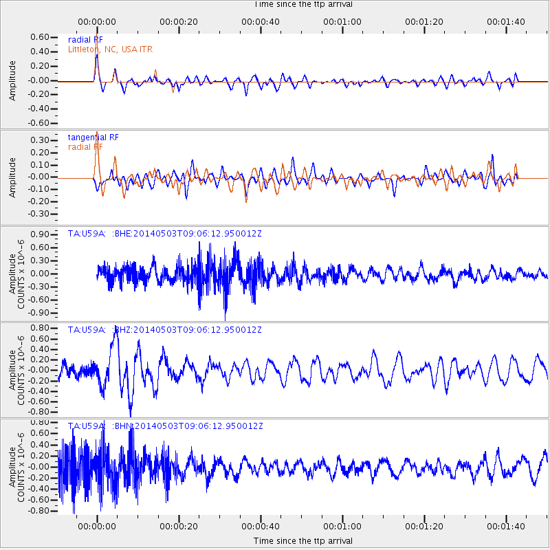
U59A Littleton, NC, USA - Earthquake Result Viewer
*The percent match for this event was below the threshold and hence no stack was calculated.
| Earthquake location: |
Northern Alaska |
| Earthquake latitude/longitude: |
67.6/-162.2 |
| Earthquake time(UTC): |
2014/05/03 (123) 08:57:12 GMT |
| Earthquake Depth: |
0.9 km |
| Earthquake Magnitude: |
5.5 MB |
| Earthquake Catalog/Contributor: |
NEIC PDE/NEIC COMCAT |
|
| Network: |
TA USArray Transportable Network (new EarthScope stations) |
| Station: |
U59A Littleton, NC, USA |
| Lat/Lon: |
36.35 N/77.79 W |
| Elevation: |
99 m |
|
| Distance: |
54.9 deg |
| Az: |
79.197 deg |
| Baz: |
332.241 deg |
| Ray Param: |
$rayparam |
*The percent match for this event was below the threshold and hence was not used in the summary stack. |
|
| Radial Match: |
53.056595 % |
| Radial Bump: |
400 |
| Transverse Match: |
53.949627 % |
| Transverse Bump: |
400 |
| SOD ConfigId: |
626651 |
| Insert Time: |
2014-05-17 09:49:29.729 +0000 |
| GWidth: |
2.5 |
| Max Bumps: |
400 |
| Tol: |
0.001 |
|
Signal To Noise
| Channel | StoN | STA | LTA |
| TA:U59A: :BHZ:20140503T09:06:12.950012Z | 3.686855 | 3.98639E-7 | 1.08124404E-7 |
| TA:U59A: :BHN:20140503T09:06:12.950012Z | 1.5952578 | 3.4594652E-7 | 2.1685933E-7 |
| TA:U59A: :BHE:20140503T09:06:12.950012Z | 1.9850334 | 3.557772E-7 | 1.7922981E-7 |
| Arrivals |
| Ps | |
| PpPs | |
| PsPs/PpSs | |


