You are here: Home > Network List > TA - USArray Transportable Network (new EarthScope stations) Stations List
> Station Y57A Sumter, SC, USA > Earthquake Result Viewer
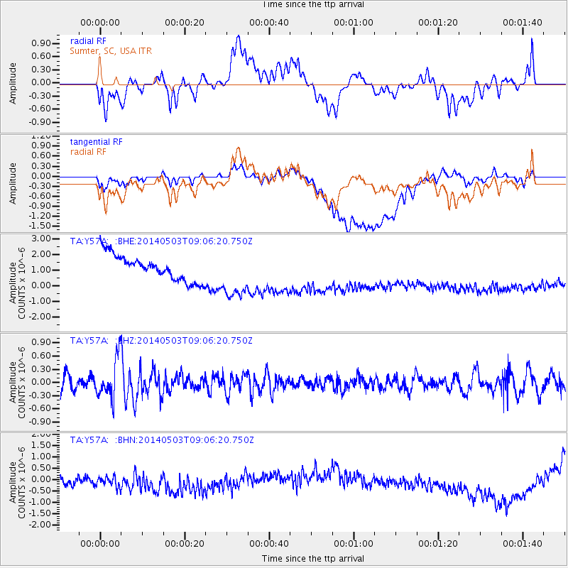
Y57A Sumter, SC, USA - Earthquake Result Viewer
*The percent match for this event was below the threshold and hence no stack was calculated.
| Earthquake location: |
Northern Alaska |
| Earthquake latitude/longitude: |
67.6/-162.2 |
| Earthquake time(UTC): |
2014/05/03 (123) 08:57:12 GMT |
| Earthquake Depth: |
0.9 km |
| Earthquake Magnitude: |
5.5 MB |
| Earthquake Catalog/Contributor: |
NEIC PDE/NEIC COMCAT |
|
| Network: |
TA USArray Transportable Network (new EarthScope stations) |
| Station: |
Y57A Sumter, SC, USA |
| Lat/Lon: |
34.02 N/80.39 W |
| Elevation: |
56 m |
|
| Distance: |
56.0 deg |
| Az: |
82.797 deg |
| Baz: |
332.794 deg |
| Ray Param: |
$rayparam |
*The percent match for this event was below the threshold and hence was not used in the summary stack. |
|
| Radial Match: |
9.8200445 % |
| Radial Bump: |
400 |
| Transverse Match: |
11.77533 % |
| Transverse Bump: |
400 |
| SOD ConfigId: |
626651 |
| Insert Time: |
2014-05-17 09:51:28.807 +0000 |
| GWidth: |
2.5 |
| Max Bumps: |
400 |
| Tol: |
0.001 |
|
Signal To Noise
| Channel | StoN | STA | LTA |
| TA:Y57A: :BHZ:20140503T09:06:20.750Z | 2.2323456 | 4.632761E-7 | 2.0752884E-7 |
| TA:Y57A: :BHN:20140503T09:06:20.750Z | 1.2209239 | 8.575707E-7 | 7.023949E-7 |
| TA:Y57A: :BHE:20140503T09:06:20.750Z | 1.9404438 | 1.5761129E-6 | 8.1224357E-7 |
| Arrivals |
| Ps | |
| PpPs | |
| PsPs/PpSs | |


