You are here: Home > Network List > II - Global Seismograph Network (GSN - IRIS/IDA) Stations List
> Station PFO Pinon Flat, California, USA > Earthquake Result Viewer
PFO Pinon Flat, California, USA - Earthquake Result Viewer

| Earthquake location: |
Santa Cruz Islands |
| Earthquake latitude/longitude: |
-12.9/166.7 |
| Earthquake time(UTC): |
1999/02/06 (037) 21:47:59 GMT |
| Earthquake Depth: |
90 km |
| Earthquake Magnitude: |
6.3 MB, 7.3 MS, 7.4 MW, 7.0 ME |
| Earthquake Catalog/Contributor: |
WHDF/NEIC |
|
| Network: |
II Global Seismograph Network (GSN - IRIS/IDA) |
| Station: |
PFO Pinon Flat, California, USA |
| Lat/Lon: |
33.61 N/116.46 W |
| Elevation: |
1280 m |
|
| Distance: |
86.4 deg |
| Az: |
54.517 deg |
| Baz: |
252.101 deg |
| Ray Param: |
0.04392015 |
| Estimated Moho Depth: |
29.75 km |
| Estimated Crust Vp/Vs: |
1.65 |
| Assumed Crust Vp: |
6.264 km/s |
| Estimated Crust Vs: |
3.79 km/s |
| Estimated Crust Poisson's Ratio: |
0.21 |
|
| Radial Match: |
96.46956 % |
| Radial Bump: |
245 |
| Transverse Match: |
90.41593 % |
| Transverse Bump: |
400 |
| SOD ConfigId: |
4480 |
| Insert Time: |
2010-03-01 21:42:50.925 +0000 |
| GWidth: |
2.5 |
| Max Bumps: |
400 |
| Tol: |
0.001 |
|
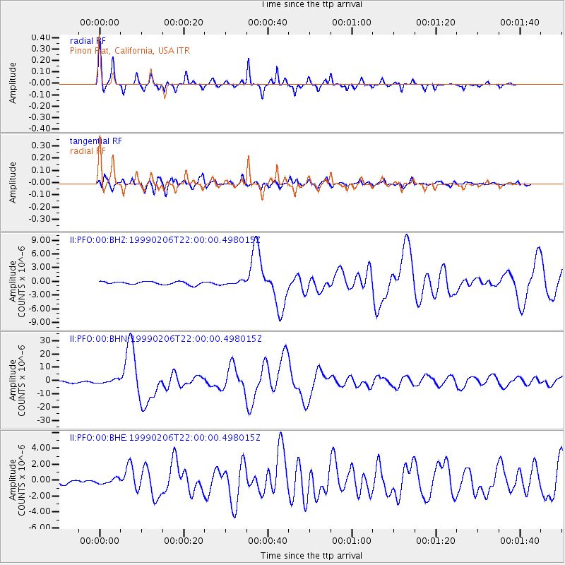
Signal To Noise
| Channel | StoN | STA | LTA |
| II:PFO:00:BHN:19990206T22:00:00.498015Z | 2.5918667 | 1.4723952E-6 | 5.680829E-7 |
| II:PFO:00:BHE:19990206T22:00:00.498015Z | 0.72652066 | 3.2597285E-7 | 4.4867664E-7 |
| II:PFO:00:BHZ:19990206T22:00:00.498015Z | 1.1405327 | 3.7040016E-7 | 3.2476066E-7 |
| Arrivals |
| Ps | 3.2 SECOND |
| PpPs | 12 SECOND |
| PsPs/PpSs | 15 SECOND |


