You are here: Home > Network List > TA - USArray Transportable Network (new EarthScope stations) Stations List
> Station N23A Red Feather Lakes, CO, USA > Earthquake Result Viewer
N23A Red Feather Lakes, CO, USA - Earthquake Result Viewer
*The percent match for this event was below the threshold and hence no stack was calculated.
| Earthquake location: |
Santa Cruz Islands Region |
| Earthquake latitude/longitude: |
-10.7/164.2 |
| Earthquake time(UTC): |
2015/02/18 (049) 09:32:26 GMT |
| Earthquake Depth: |
10 km |
| Earthquake Magnitude: |
5.9 MB |
| Earthquake Catalog/Contributor: |
NEIC PDE/NEIC COMCAT |
|
| Network: |
TA USArray Transportable Network (new EarthScope stations) |
| Station: |
N23A Red Feather Lakes, CO, USA |
| Lat/Lon: |
40.89 N/105.94 W |
| Elevation: |
2458 m |
|
| Distance: |
96.9 deg |
| Az: |
49.778 deg |
| Baz: |
261.815 deg |
| Ray Param: |
$rayparam |
*The percent match for this event was below the threshold and hence was not used in the summary stack. |
|
| Radial Match: |
57.26168 % |
| Radial Bump: |
400 |
| Transverse Match: |
45.272335 % |
| Transverse Bump: |
393 |
| SOD ConfigId: |
7019011 |
| Insert Time: |
2019-04-16 22:26:14.314 +0000 |
| GWidth: |
2.5 |
| Max Bumps: |
400 |
| Tol: |
0.001 |
|
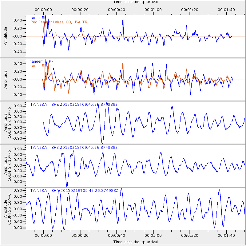
Signal To Noise
| Channel | StoN | STA | LTA |
| TA:N23A: :BHZ:20150218T09:45:26.874988Z | 0.80375457 | 1.8822193E-7 | 2.3417837E-7 |
| TA:N23A: :BHN:20150218T09:45:26.874988Z | 1.4736481 | 5.273404E-7 | 3.5784691E-7 |
| TA:N23A: :BHE:20150218T09:45:26.874988Z | 2.5200849 | 7.850099E-7 | 3.1150137E-7 |
| Arrivals |
| Ps | |
| PpPs | |
| PsPs/PpSs | |


