You are here: Home > Network List > TA - USArray Transportable Network (new EarthScope stations) Stations List
> Station O03E Paynes Creek, CA, USA > Earthquake Result Viewer
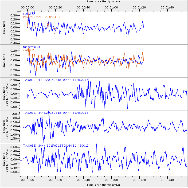
O03E Paynes Creek, CA, USA - Earthquake Result Viewer
*The percent match for this event was below the threshold and hence no stack was calculated.
| Earthquake location: |
Santa Cruz Islands Region |
| Earthquake latitude/longitude: |
-10.7/164.2 |
| Earthquake time(UTC): |
2015/02/18 (049) 09:32:26 GMT |
| Earthquake Depth: |
10 km |
| Earthquake Magnitude: |
5.9 MB |
| Earthquake Catalog/Contributor: |
NEIC PDE/NEIC COMCAT |
|
| Network: |
TA USArray Transportable Network (new EarthScope stations) |
| Station: |
O03E Paynes Creek, CA, USA |
| Lat/Lon: |
40.29 N/121.80 W |
| Elevation: |
967 m |
|
| Distance: |
85.0 deg |
| Az: |
47.581 deg |
| Baz: |
251.534 deg |
| Ray Param: |
$rayparam |
*The percent match for this event was below the threshold and hence was not used in the summary stack. |
|
| Radial Match: |
77.17456 % |
| Radial Bump: |
400 |
| Transverse Match: |
67.25663 % |
| Transverse Bump: |
400 |
| SOD ConfigId: |
7019011 |
| Insert Time: |
2019-04-16 22:26:14.990 +0000 |
| GWidth: |
2.5 |
| Max Bumps: |
400 |
| Tol: |
0.001 |
|
Signal To Noise
| Channel | StoN | STA | LTA |
| TA:O03E: :HHZ:20150218T09:44:31.46001Z | 2.823546 | 4.029871E-7 | 1.4272376E-7 |
| TA:O03E: :HHN:20150218T09:44:31.46001Z | 1.4701574 | 1.4067164E-7 | 9.5684754E-8 |
| TA:O03E: :HHE:20150218T09:44:31.46001Z | 0.9579288 | 1.527968E-7 | 1.5950748E-7 |
| Arrivals |
| Ps | |
| PpPs | |
| PsPs/PpSs | |


