You are here: Home > Network List > TA - USArray Transportable Network (new EarthScope stations) Stations List
> Station O03E Paynes Creek, CA, USA > Earthquake Result Viewer
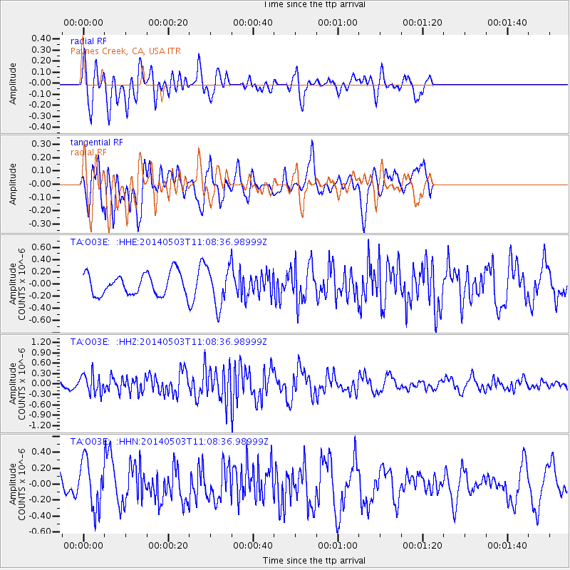
O03E Paynes Creek, CA, USA - Earthquake Result Viewer
*The percent match for this event was below the threshold and hence no stack was calculated.
| Earthquake location: |
Volcano Islands, Japan Region |
| Earthquake latitude/longitude: |
22.3/144.0 |
| Earthquake time(UTC): |
2014/05/03 (123) 10:57:11 GMT |
| Earthquake Depth: |
69 km |
| Earthquake Magnitude: |
5.5 MB |
| Earthquake Catalog/Contributor: |
NEIC PDE/NEIC COMCAT |
|
| Network: |
TA USArray Transportable Network (new EarthScope stations) |
| Station: |
O03E Paynes Creek, CA, USA |
| Lat/Lon: |
40.29 N/121.80 W |
| Elevation: |
967 m |
|
| Distance: |
79.0 deg |
| Az: |
51.004 deg |
| Baz: |
289.797 deg |
| Ray Param: |
$rayparam |
*The percent match for this event was below the threshold and hence was not used in the summary stack. |
|
| Radial Match: |
62.544193 % |
| Radial Bump: |
400 |
| Transverse Match: |
61.15118 % |
| Transverse Bump: |
400 |
| SOD ConfigId: |
626651 |
| Insert Time: |
2014-05-17 11:26:20.022 +0000 |
| GWidth: |
2.5 |
| Max Bumps: |
400 |
| Tol: |
0.001 |
|
Signal To Noise
| Channel | StoN | STA | LTA |
| TA:O03E: :HHZ:20140503T11:08:36.98999Z | 3.1279345 | 2.7352763E-7 | 8.744673E-8 |
| TA:O03E: :HHN:20140503T11:08:36.98999Z | 1.6954124 | 3.0595038E-7 | 1.804578E-7 |
| TA:O03E: :HHE:20140503T11:08:36.98999Z | 1.8094095 | 3.1704252E-7 | 1.7521877E-7 |
| Arrivals |
| Ps | |
| PpPs | |
| PsPs/PpSs | |


