PFO Pinon Flat, California, USA - Earthquake Result Viewer
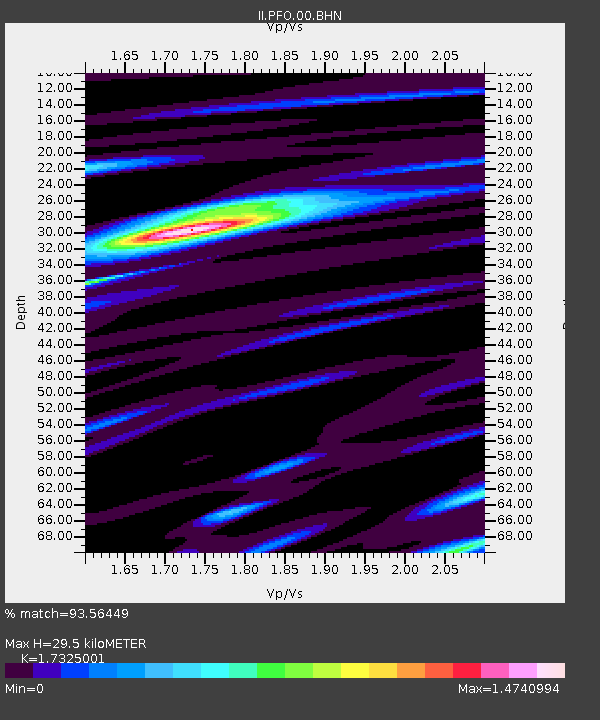
Earthquake location: Andreanof Islands, Aleutian Is.
Earthquake latitude/longitude: 51.2/-179.3
Earthquake time(UTC): 2006/07/08 (189) 20:40:00 GMT
Earthquake Depth: 22 km
Earthquake Magnitude: 6.2 MB, 6.4 MS, 6.6 MW, 6.6 MW
Earthquake Catalog/Contributor: WHDF/NEIC
Network: II Global Seismograph Network (GSN - IRIS/IDA)
Station: PFO Pinon Flat, California, USA
Lat/Lon: 33.61 N/116.46 W
Elevation: 1280 m
Distance: 48.1 deg
Az: 86.107 deg
Baz: 311.242 deg
Ray Param: 0.06954146
Estimated Moho Depth: 29.5 km
Estimated Crust Vp/Vs: 1.73
Assumed Crust Vp: 6.264 km/s
Estimated Crust Vs: 3.615 km/s
Estimated Crust Poisson's Ratio: 0.25
Radial Match: 93.56449 %
Radial Bump: 388
Transverse Match: 83.47857 %
Transverse Bump: 400
SOD ConfigId: 2665
Insert Time: 2010-03-01 21:43:24.430 +0000
GWidth: 2.5
Max Bumps: 400
Tol: 0.001

Signal To Noise

ChannelStoNSTALTA
II:PFO:00:BHN:20060708T20:48:08.150013Z2.49604561.7962017E-77.19619E-8
II:PFO:00:BHE:20060708T20:48:08.150013Z1.72647741.5050954E-78.717724E-8
II:PFO:00:BHZ:20060708T20:48:08.150013Z3.75965363.7212814E-79.897938E-8
Arrivals
Ps3.7 SECOND
PpPs12 SECOND
PsPs/PpSs16 SECOND