You are here: Home > Network List > ZJ12 - Transantarctic Mountains Northern Network Stations List
> Station DUBY Mt Kring, Antarctica > Earthquake Result Viewer
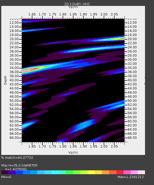
DUBY Mt Kring, Antarctica - Earthquake Result Viewer
| Earthquake location: |
Santa Cruz Islands Region |
| Earthquake latitude/longitude: |
-10.7/164.2 |
| Earthquake time(UTC): |
2015/02/18 (049) 09:32:26 GMT |
| Earthquake Depth: |
10 km |
| Earthquake Magnitude: |
5.9 MB |
| Earthquake Catalog/Contributor: |
NEIC PDE/NEIC COMCAT |
|
| Network: |
ZJ Transantarctic Mountains Northern Network |
| Station: |
DUBY Mt Kring, Antarctica |
| Lat/Lon: |
74.99 S/158.08 E |
| Elevation: |
1508 m |
|
| Distance: |
64.3 deg |
| Az: |
181.754 deg |
| Baz: |
6.625 deg |
| Ray Param: |
0.059000332 |
| Estimated Moho Depth: |
35.0 km |
| Estimated Crust Vp/Vs: |
1.62 |
| Assumed Crust Vp: |
6.182 km/s |
| Estimated Crust Vs: |
3.81 km/s |
| Estimated Crust Poisson's Ratio: |
0.19 |
|
| Radial Match: |
84.07732 % |
| Radial Bump: |
393 |
| Transverse Match: |
62.447266 % |
| Transverse Bump: |
400 |
| SOD ConfigId: |
7019011 |
| Insert Time: |
2019-04-16 22:28:27.929 +0000 |
| GWidth: |
2.5 |
| Max Bumps: |
400 |
| Tol: |
0.001 |
|

Signal To Noise
| Channel | StoN | STA | LTA |
| ZJ:DUBY: :HHZ:20150218T09:42:31.429004Z | 3.2372575 | 8.093646E-7 | 2.5001552E-7 |
| ZJ:DUBY: :HHN:20150218T09:42:31.429004Z | 1.2139348 | 3.5245222E-7 | 2.9033868E-7 |
| ZJ:DUBY: :HHE:20150218T09:42:31.429004Z | 0.73407733 | 1.0471989E-7 | 1.4265511E-7 |
| Arrivals |
| Ps | 3.7 SECOND |
| PpPs | 14 SECOND |
| PsPs/PpSs | 18 SECOND |


