You are here: Home > Network List > II - Global Seismograph Network (GSN - IRIS/IDA) Stations List
> Station PFO Pinon Flat, California, USA > Earthquake Result Viewer
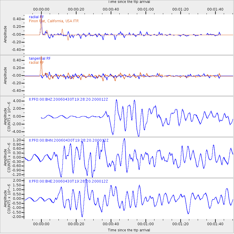
PFO Pinon Flat, California, USA - Earthquake Result Viewer

| Earthquake location: |
Near Coast Of Northern Chile |
| Earthquake latitude/longitude: |
-27.0/-71.0 |
| Earthquake time(UTC): |
2006/04/30 (120) 19:17:17 GMT |
| Earthquake Depth: |
27 km |
| Earthquake Magnitude: |
6.0 MB, 6.4 MS, 6.7 MW, 6.6 MW |
| Earthquake Catalog/Contributor: |
WHDF/NEIC |
|
| Network: |
II Global Seismograph Network (GSN - IRIS/IDA) |
| Station: |
PFO Pinon Flat, California, USA |
| Lat/Lon: |
33.61 N/116.46 W |
| Elevation: |
1280 m |
|
| Distance: |
74.2 deg |
| Az: |
321.779 deg |
| Baz: |
138.594 deg |
| Ray Param: |
0.052486952 |
| Estimated Moho Depth: |
66.0 km |
| Estimated Crust Vp/Vs: |
1.72 |
| Assumed Crust Vp: |
6.264 km/s |
| Estimated Crust Vs: |
3.642 km/s |
| Estimated Crust Poisson's Ratio: |
0.24 |
|
| Radial Match: |
96.61876 % |
| Radial Bump: |
315 |
| Transverse Match: |
89.952484 % |
| Transverse Bump: |
400 |
| SOD ConfigId: |
2669 |
| Insert Time: |
2010-03-01 21:43:41.305 +0000 |
| GWidth: |
2.5 |
| Max Bumps: |
400 |
| Tol: |
0.001 |
|
Signal To Noise
| Channel | StoN | STA | LTA |
| II:PFO:00:BHN:20060430T19:28:20.200012Z | 1.1438279 | 1.6335748E-7 | 1.4281649E-7 |
| II:PFO:00:BHE:20060430T19:28:20.200012Z | 0.93001777 | 1.3161578E-7 | 1.4151965E-7 |
| II:PFO:00:BHZ:20060430T19:28:20.200012Z | 0.5114259 | 1.18420026E-7 | 2.3154875E-7 |
| Arrivals |
| Ps | 7.8 SECOND |
| PpPs | 28 SECOND |
| PsPs/PpSs | 36 SECOND |


