You are here: Home > Network List > IU - Global Seismograph Network (GSN - IRIS/USGS) Stations List
> Station GUMO Guam, Mariana Islands > Earthquake Result Viewer
GUMO Guam, Mariana Islands - Earthquake Result Viewer
| Earthquake location: |
South Of Fiji Islands |
| Earthquake latitude/longitude: |
-24.6/179.1 |
| Earthquake time(UTC): |
2014/05/04 (124) 09:15:53 GMT |
| Earthquake Depth: |
528 km |
| Earthquake Magnitude: |
6.6 MWP, 6.8 MI |
| Earthquake Catalog/Contributor: |
NEIC PDE/NEIC COMCAT |
|
| Network: |
IU Global Seismograph Network (GSN - IRIS/USGS) |
| Station: |
GUMO Guam, Mariana Islands |
| Lat/Lon: |
13.59 N/144.87 E |
| Elevation: |
170 m |
|
| Distance: |
50.6 deg |
| Az: |
314.953 deg |
| Baz: |
138.525 deg |
| Ray Param: |
0.06560277 |
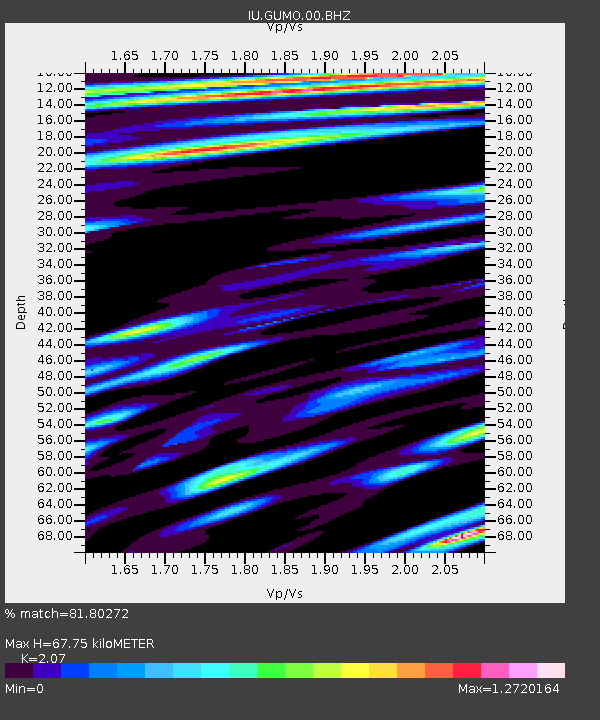
| Estimated Moho Depth: |
67.75 km |
| Estimated Crust Vp/Vs: |
2.07 |
| Assumed Crust Vp: |
4.802 km/s |
| Estimated Crust Vs: |
2.32 km/s |
| Estimated Crust Poisson's Ratio: |
0.35 |
|
| Radial Match: |
81.80272 % |
| Radial Bump: |
400 |
| Transverse Match: |
66.440765 % |
| Transverse Bump: |
400 |
| SOD ConfigId: |
626651 |
| Insert Time: |
2014-05-18 09:55:46.947 +0000 |
| GWidth: |
2.5 |
| Max Bumps: |
400 |
| Tol: |
0.001 |
|

Signal To Noise
| Channel | StoN | STA | LTA |
| IU:GUMO:00:BHZ:20140504T09:23:32.318993Z | 15.845016 | 1.1276101E-5 | 7.1164976E-7 |
| IU:GUMO:00:BH1:20140504T09:23:32.318993Z | 5.3753915 | 3.3974954E-6 | 6.320462E-7 |
| IU:GUMO:00:BH2:20140504T09:23:32.318993Z | 4.0397487 | 1.9760482E-6 | 4.8915126E-7 |
| Arrivals |
| Ps | 15 SECOND |
| PpPs | 42 SECOND |
| PsPs/PpSs | 58 SECOND |


