You are here: Home > Network List > TA - USArray Transportable Network (new EarthScope stations) Stations List
> Station O03E Paynes Creek, CA, USA > Earthquake Result Viewer
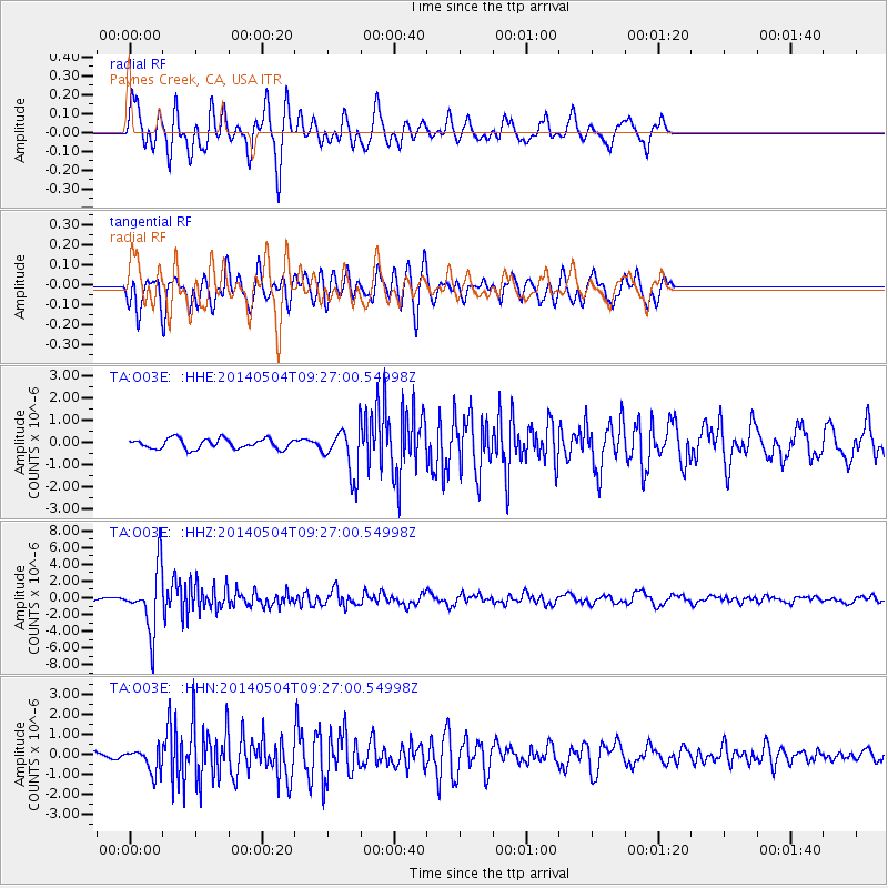
O03E Paynes Creek, CA, USA - Earthquake Result Viewer
*The percent match for this event was below the threshold and hence no stack was calculated.
| Earthquake location: |
South Of Fiji Islands |
| Earthquake latitude/longitude: |
-24.6/179.1 |
| Earthquake time(UTC): |
2014/05/04 (124) 09:15:53 GMT |
| Earthquake Depth: |
528 km |
| Earthquake Magnitude: |
6.6 MWP, 6.8 MI |
| Earthquake Catalog/Contributor: |
NEIC PDE/NEIC COMCAT |
|
| Network: |
TA USArray Transportable Network (new EarthScope stations) |
| Station: |
O03E Paynes Creek, CA, USA |
| Lat/Lon: |
40.29 N/121.80 W |
| Elevation: |
967 m |
|
| Distance: |
84.8 deg |
| Az: |
41.23 deg |
| Baz: |
231.641 deg |
| Ray Param: |
$rayparam |
*The percent match for this event was below the threshold and hence was not used in the summary stack. |
|
| Radial Match: |
72.17118 % |
| Radial Bump: |
400 |
| Transverse Match: |
70.226425 % |
| Transverse Bump: |
400 |
| SOD ConfigId: |
626651 |
| Insert Time: |
2014-05-18 10:04:16.992 +0000 |
| GWidth: |
2.5 |
| Max Bumps: |
400 |
| Tol: |
0.001 |
|
Signal To Noise
| Channel | StoN | STA | LTA |
| TA:O03E: :HHZ:20140504T09:27:00.54998Z | 17.001726 | 3.66773E-6 | 2.1572691E-7 |
| TA:O03E: :HHN:20140504T09:27:00.54998Z | 1.9010216 | 6.103873E-7 | 3.2108383E-7 |
| TA:O03E: :HHE:20140504T09:27:00.54998Z | 4.5174303 | 1.0176507E-6 | 2.2527203E-7 |
| Arrivals |
| Ps | |
| PpPs | |
| PsPs/PpSs | |


