You are here: Home > Network List > UW - Pacific Northwest Regional Seismic Network Stations List
> Station MRBL Marblemount, WA, USA > Earthquake Result Viewer
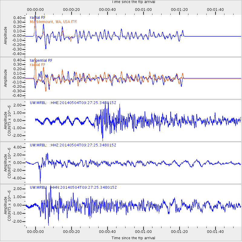
MRBL Marblemount, WA, USA - Earthquake Result Viewer
*The percent match for this event was below the threshold and hence no stack was calculated.
| Earthquake location: |
South Of Fiji Islands |
| Earthquake latitude/longitude: |
-24.6/179.1 |
| Earthquake time(UTC): |
2014/05/04 (124) 09:15:53 GMT |
| Earthquake Depth: |
528 km |
| Earthquake Magnitude: |
6.6 MWP, 6.8 MI |
| Earthquake Catalog/Contributor: |
NEIC PDE/NEIC COMCAT |
|
| Network: |
UW Pacific Northwest Regional Seismic Network |
| Station: |
MRBL Marblemount, WA, USA |
| Lat/Lon: |
48.52 N/121.48 W |
| Elevation: |
75 m |
|
| Distance: |
90.1 deg |
| Az: |
34.923 deg |
| Baz: |
231.584 deg |
| Ray Param: |
$rayparam |
*The percent match for this event was below the threshold and hence was not used in the summary stack. |
|
| Radial Match: |
58.125633 % |
| Radial Bump: |
400 |
| Transverse Match: |
60.674206 % |
| Transverse Bump: |
400 |
| SOD ConfigId: |
626651 |
| Insert Time: |
2014-05-18 10:09:51.188 +0000 |
| GWidth: |
2.5 |
| Max Bumps: |
400 |
| Tol: |
0.001 |
|
Signal To Noise
| Channel | StoN | STA | LTA |
| UW:MRBL: :HHZ:20140504T09:27:25.348015Z | 3.592015 | 1.308656E-6 | 3.6432365E-7 |
| UW:MRBL: :HHN:20140504T09:27:25.348015Z | 2.3969774 | 4.3473804E-7 | 1.8136926E-7 |
| UW:MRBL: :HHE:20140504T09:27:25.348015Z | 1.7075396 | 4.603957E-7 | 2.6962522E-7 |
| Arrivals |
| Ps | |
| PpPs | |
| PsPs/PpSs | |


