You are here: Home > Network List > UW - Pacific Northwest Regional Seismic Network Stations List
> Station UMAT Pilot Rock, OR, USA > Earthquake Result Viewer
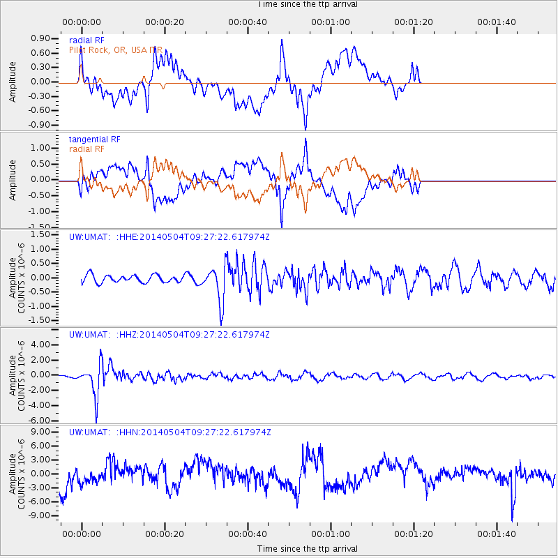
UMAT Pilot Rock, OR, USA - Earthquake Result Viewer
*The percent match for this event was below the threshold and hence no stack was calculated.
| Earthquake location: |
South Of Fiji Islands |
| Earthquake latitude/longitude: |
-24.6/179.1 |
| Earthquake time(UTC): |
2014/05/04 (124) 09:15:53 GMT |
| Earthquake Depth: |
528 km |
| Earthquake Magnitude: |
6.6 MWP, 6.8 MI |
| Earthquake Catalog/Contributor: |
NEIC PDE/NEIC COMCAT |
|
| Network: |
UW Pacific Northwest Regional Seismic Network |
| Station: |
UMAT Pilot Rock, OR, USA |
| Lat/Lon: |
45.29 N/118.96 W |
| Elevation: |
1318 m |
|
| Distance: |
89.5 deg |
| Az: |
38.539 deg |
| Baz: |
233.434 deg |
| Ray Param: |
$rayparam |
*The percent match for this event was below the threshold and hence was not used in the summary stack. |
|
| Radial Match: |
61.941975 % |
| Radial Bump: |
400 |
| Transverse Match: |
61.650738 % |
| Transverse Bump: |
400 |
| SOD ConfigId: |
626651 |
| Insert Time: |
2014-05-18 10:10:30.869 +0000 |
| GWidth: |
2.5 |
| Max Bumps: |
400 |
| Tol: |
0.001 |
|
Signal To Noise
| Channel | StoN | STA | LTA |
| UW:UMAT: :HHZ:20140504T09:27:22.617974Z | 10.678997 | 2.0977407E-6 | 1.9643612E-7 |
| UW:UMAT: :HHN:20140504T09:27:22.617974Z | 0.77403325 | 1.8283588E-6 | 2.3621192E-6 |
| UW:UMAT: :HHE:20140504T09:27:22.617974Z | 4.8873844 | 6.4217124E-7 | 1.3139365E-7 |
| Arrivals |
| Ps | |
| PpPs | |
| PsPs/PpSs | |


