You are here: Home > Network List > WY - Yellowstone Wyoming Seismic Network Stations List
> Station YHH Holmes Hill, YNP, WY, USA > Earthquake Result Viewer
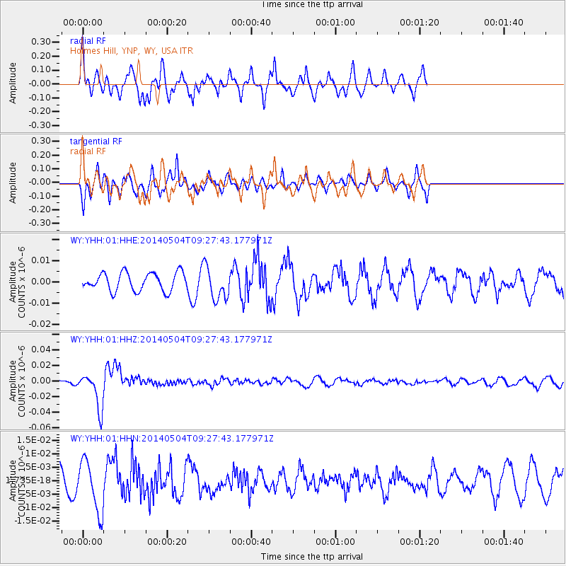
YHH Holmes Hill, YNP, WY, USA - Earthquake Result Viewer
*The percent match for this event was below the threshold and hence no stack was calculated.
| Earthquake location: |
South Of Fiji Islands |
| Earthquake latitude/longitude: |
-24.6/179.1 |
| Earthquake time(UTC): |
2014/05/04 (124) 09:15:53 GMT |
| Earthquake Depth: |
528 km |
| Earthquake Magnitude: |
6.6 MWP, 6.8 MI |
| Earthquake Catalog/Contributor: |
NEIC PDE/NEIC COMCAT |
|
| Network: |
WY Yellowstone Wyoming Seismic Network |
| Station: |
YHH Holmes Hill, YNP, WY, USA |
| Lat/Lon: |
44.79 N/110.85 W |
| Elevation: |
2717 m |
|
| Distance: |
94.0 deg |
| Az: |
42.15 deg |
| Baz: |
239.046 deg |
| Ray Param: |
$rayparam |
*The percent match for this event was below the threshold and hence was not used in the summary stack. |
|
| Radial Match: |
63.4359 % |
| Radial Bump: |
360 |
| Transverse Match: |
61.615273 % |
| Transverse Bump: |
400 |
| SOD ConfigId: |
626651 |
| Insert Time: |
2014-05-18 10:10:48.520 +0000 |
| GWidth: |
2.5 |
| Max Bumps: |
400 |
| Tol: |
0.001 |
|
Signal To Noise
| Channel | StoN | STA | LTA |
| WY:YHH:01:HHZ:20140504T09:27:43.177971Z | 9.560375 | 2.404925E-8 | 2.5155131E-9 |
| WY:YHH:01:HHN:20140504T09:27:43.177971Z | 2.2395353 | 9.766608E-9 | 4.360998E-9 |
| WY:YHH:01:HHE:20140504T09:27:43.177971Z | 1.7960328 | 7.594467E-9 | 4.2284682E-9 |
| Arrivals |
| Ps | |
| PpPs | |
| PsPs/PpSs | |


