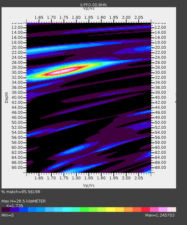
PFO Pinon Flat, California, USA - Earthquake Result Viewer
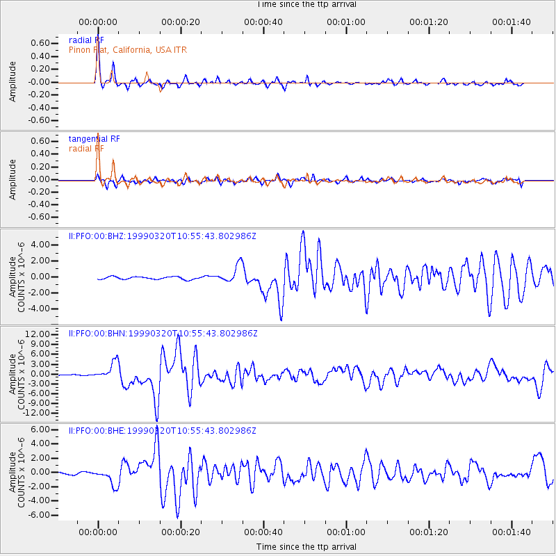
Earthquake location: Andreanof Islands, Aleutian Is.
Earthquake latitude/longitude: 51.6/-177.7
Earthquake time(UTC): 1999/03/20 (079) 10:47:45 GMT
Earthquake Depth: 33 km
Earthquake Magnitude: 6.3 MB, 6.8 MS, 6.9 MW, 6.8 ME
Earthquake Catalog/Contributor: WHDF/NEIC
Network: II Global Seismograph Network (GSN - IRIS/IDA)
Station: PFO Pinon Flat, California, USA
Lat/Lon: 33.61 N/116.46 W
Elevation: 1280 m
Distance: 47.1 deg
Az: 87.678 deg
Baz: 311.672 deg
Ray Param: 0.0701781
Estimated Moho Depth: 29.5 km
Estimated Crust Vp/Vs: 1.74
Assumed Crust Vp: 6.264 km/s
Estimated Crust Vs: 3.61 km/s
Estimated Crust Poisson's Ratio: 0.25
Radial Match: 95.56199 %
Radial Bump: 259
Transverse Match: 81.43263 %
Transverse Bump: 400
SOD ConfigId: 4480
Insert Time: 2010-03-01 21:45:06.613 +0000
GWidth: 2.5
Max Bumps: 400
Tol: 0.001

Signal To Noise

ChannelStoNSTALTA
II:PFO:00:BHN:19990320T10:55:43.802986Z8.9388872.7998092E-63.1321676E-7
II:PFO:00:BHE:19990320T10:55:43.802986Z6.27510261.2285197E-61.9577685E-7
II:PFO:00:BHZ:19990320T10:55:43.802986Z7.1220921.1787556E-61.6550693E-7
Arrivals
Ps3.7 SECOND
PpPs12 SECOND
PsPs/PpSs16 SECOND