You are here: Home > Network List > II - Global Seismograph Network (GSN - IRIS/IDA) Stations List
> Station PFO Pinon Flat, California, USA > Earthquake Result Viewer
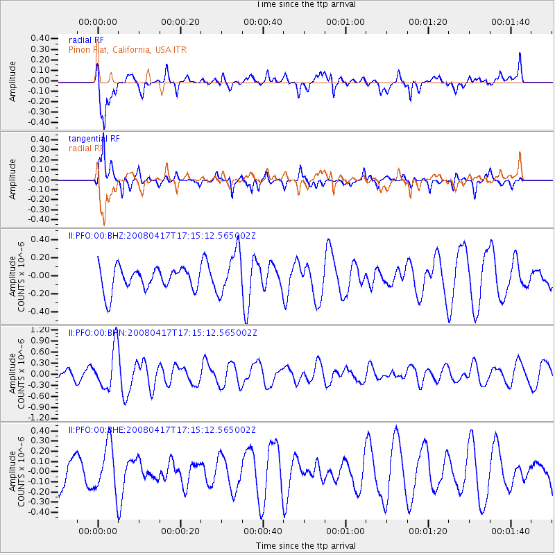
PFO Pinon Flat, California, USA - Earthquake Result Viewer
*The percent match for this event was below the threshold and hence no stack was calculated.
| Earthquake location: |
Mariana Islands Region |
| Earthquake latitude/longitude: |
15.9/144.9 |
| Earthquake time(UTC): |
2008/04/17 (108) 17:02:52 GMT |
| Earthquake Depth: |
10 km |
| Earthquake Magnitude: |
5.5 MB, 5.2 MS, 5.5 MW, 5.5 MW |
| Earthquake Catalog/Contributor: |
WHDF/NEIC |
|
| Network: |
II Global Seismograph Network (GSN - IRIS/IDA) |
| Station: |
PFO Pinon Flat, California, USA |
| Lat/Lon: |
33.61 N/116.46 W |
| Elevation: |
1280 m |
|
| Distance: |
88.3 deg |
| Az: |
55.623 deg |
| Baz: |
287.88 deg |
| Ray Param: |
$rayparam |
*The percent match for this event was below the threshold and hence was not used in the summary stack. |
|
| Radial Match: |
49.91906 % |
| Radial Bump: |
400 |
| Transverse Match: |
63.19838 % |
| Transverse Bump: |
387 |
| SOD ConfigId: |
2504 |
| Insert Time: |
2010-03-01 21:45:25.961 +0000 |
| GWidth: |
2.5 |
| Max Bumps: |
400 |
| Tol: |
0.001 |
|
Signal To Noise
| Channel | StoN | STA | LTA |
| II:PFO:00:BHN:20080417T17:15:12.565002Z | 3.5307198 | 5.8307165E-7 | 1.6514242E-7 |
| II:PFO:00:BHE:20080417T17:15:12.565002Z | 1.6168069 | 2.460226E-7 | 1.5216573E-7 |
| II:PFO:00:BHZ:20080417T17:15:12.565002Z | 1.9340843 | 2.4374185E-7 | 1.2602442E-7 |
| Arrivals |
| Ps | |
| PpPs | |
| PsPs/PpSs | |


