You are here: Home > Network List > II - Global Seismograph Network (GSN - IRIS/IDA) Stations List
> Station PFO Pinon Flat, California, USA > Earthquake Result Viewer
PFO Pinon Flat, California, USA - Earthquake Result Viewer
*The percent match for this event was below the threshold and hence no stack was calculated.
| Earthquake location: |
Solomon Islands |
| Earthquake latitude/longitude: |
-9.3/158.7 |
| Earthquake time(UTC): |
1997/10/06 (279) 20:52:44 GMT |
| Earthquake Depth: |
33 km |
| Earthquake Magnitude: |
5.7 MB, 5.9 MS, 6.1 UNKNOWN, 6.1 MW |
| Earthquake Catalog/Contributor: |
WHDF/NEIC |
|
| Network: |
II Global Seismograph Network (GSN - IRIS/IDA) |
| Station: |
PFO Pinon Flat, California, USA |
| Lat/Lon: |
33.61 N/116.46 W |
| Elevation: |
1280 m |
|
| Distance: |
90.8 deg |
| Az: |
56.229 deg |
| Baz: |
259.466 deg |
| Ray Param: |
$rayparam |
*The percent match for this event was below the threshold and hence was not used in the summary stack. |
|
| Radial Match: |
80.62966 % |
| Radial Bump: |
400 |
| Transverse Match: |
70.929 % |
| Transverse Bump: |
400 |
| SOD ConfigId: |
4480 |
| Insert Time: |
2010-03-01 21:45:31.474 +0000 |
| GWidth: |
2.5 |
| Max Bumps: |
400 |
| Tol: |
0.001 |
|
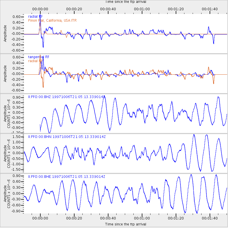
Signal To Noise
| Channel | StoN | STA | LTA |
| II:PFO:00:BHN:19971006T21:05:13.339014Z | 0.6143508 | 3.463152E-7 | 5.637092E-7 |
| II:PFO:00:BHE:19971006T21:05:13.339014Z | 0.40098298 | 2.1667792E-7 | 5.403669E-7 |
| II:PFO:00:BHZ:19971006T21:05:13.339014Z | 1.2883956 | 6.2117283E-7 | 4.82129E-7 |
| Arrivals |
| Ps | |
| PpPs | |
| PsPs/PpSs | |


