You are here: Home > Network List > II - Global Seismograph Network (GSN - IRIS/IDA) Stations List
> Station PFO Pinon Flat, California, USA > Earthquake Result Viewer
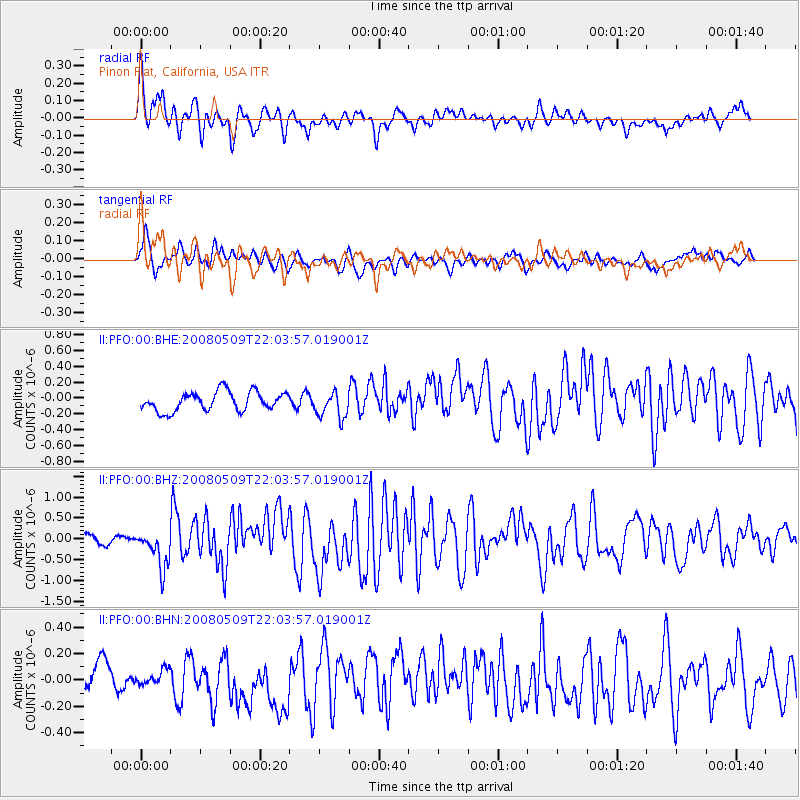
PFO Pinon Flat, California, USA - Earthquake Result Viewer
*The percent match for this event was below the threshold and hence no stack was calculated.
| Earthquake location: |
South Of Mariana Islands |
| Earthquake latitude/longitude: |
12.5/143.2 |
| Earthquake time(UTC): |
2008/05/09 (130) 21:51:29 GMT |
| Earthquake Depth: |
76 km |
| Earthquake Magnitude: |
6.1 MB, 6.7 MW, 6.7 MW |
| Earthquake Catalog/Contributor: |
WHDF/NEIC |
|
| Network: |
II Global Seismograph Network (GSN - IRIS/IDA) |
| Station: |
PFO Pinon Flat, California, USA |
| Lat/Lon: |
33.61 N/116.46 W |
| Elevation: |
1280 m |
|
| Distance: |
91.6 deg |
| Az: |
55.208 deg |
| Baz: |
286.057 deg |
| Ray Param: |
$rayparam |
*The percent match for this event was below the threshold and hence was not used in the summary stack. |
|
| Radial Match: |
85.471115 % |
| Radial Bump: |
400 |
| Transverse Match: |
54.592335 % |
| Transverse Bump: |
383 |
| SOD ConfigId: |
2504 |
| Insert Time: |
2010-03-01 21:45:35.739 +0000 |
| GWidth: |
2.5 |
| Max Bumps: |
400 |
| Tol: |
0.001 |
|
Signal To Noise
| Channel | StoN | STA | LTA |
| II:PFO:00:BHZ:20080509T22:03:57.019001Z | 3.4392881 | 4.604033E-7 | 1.3386587E-7 |
| II:PFO:00:BHN:20080509T22:03:57.019001Z | 0.5378886 | 1.1972111E-7 | 2.2257602E-7 |
| II:PFO:00:BHE:20080509T22:03:57.019001Z | 1.4038514 | 1.6872781E-7 | 1.2018923E-7 |
| Arrivals |
| Ps | |
| PpPs | |
| PsPs/PpSs | |


