You are here: Home > Network List > II - Global Seismograph Network (GSN - IRIS/IDA) Stations List
> Station PFO Pinon Flat, California, USA > Earthquake Result Viewer
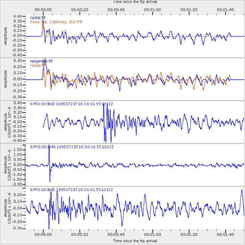
PFO Pinon Flat, California, USA - Earthquake Result Viewer
*The percent match for this event was below the threshold and hence no stack was calculated.
| Earthquake location: |
Southeast Of Honshu, Japan |
| Earthquake latitude/longitude: |
30.4/138.3 |
| Earthquake time(UTC): |
1995/07/29 (210) 16:18:44 GMT |
| Earthquake Depth: |
436 km |
| Earthquake Magnitude: |
5.5 MB, 5.6 UNKNOWN |
| Earthquake Catalog/Contributor: |
WHDF/NEIC |
|
| Network: |
II Global Seismograph Network (GSN - IRIS/IDA) |
| Station: |
PFO Pinon Flat, California, USA |
| Lat/Lon: |
33.61 N/116.46 W |
| Elevation: |
1280 m |
|
| Distance: |
85.0 deg |
| Az: |
53.924 deg |
| Baz: |
303.17 deg |
| Ray Param: |
$rayparam |
*The percent match for this event was below the threshold and hence was not used in the summary stack. |
|
| Radial Match: |
66.66231 % |
| Radial Bump: |
400 |
| Transverse Match: |
68.69975 % |
| Transverse Bump: |
400 |
| SOD ConfigId: |
4480 |
| Insert Time: |
2010-03-01 21:45:36.944 +0000 |
| GWidth: |
2.5 |
| Max Bumps: |
400 |
| Tol: |
0.001 |
|
Signal To Noise
| Channel | StoN | STA | LTA |
| II:PFO:00:BHN:19950729T16:30:01.551013Z | 7.8138113 | 5.826135E-7 | 7.456202E-8 |
| II:PFO:00:BHE:19950729T16:30:01.551013Z | 1.5724713 | 9.666588E-8 | 6.147386E-8 |
| II:PFO:00:BHZ:19950729T16:30:01.551013Z | 2.4476638 | 1.6755635E-7 | 6.845563E-8 |
| Arrivals |
| Ps | |
| PpPs | |
| PsPs/PpSs | |


