You are here: Home > Network List > AV - Alaska Volcano Observatory Stations List
> Station MAPS Pakushin Southeast, Makushin Volcano, Alaska > Earthquake Result Viewer
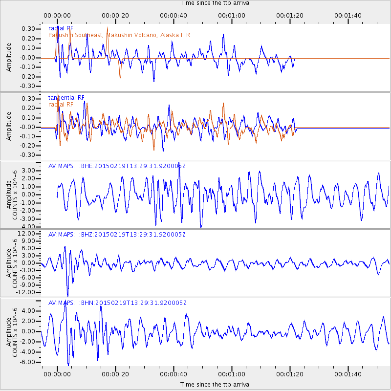
MAPS Pakushin Southeast, Makushin Volcano, Alaska - Earthquake Result Viewer
*The percent match for this event was below the threshold and hence no stack was calculated.
| Earthquake location: |
Vanuatu Islands |
| Earthquake latitude/longitude: |
-16.4/168.1 |
| Earthquake time(UTC): |
2015/02/19 (050) 13:18:32 GMT |
| Earthquake Depth: |
10 km |
| Earthquake Magnitude: |
6.5 MWP |
| Earthquake Catalog/Contributor: |
NEIC PDE/NEIC COMCAT |
|
| Network: |
AV Alaska Volcano Observatory |
| Station: |
MAPS Pakushin Southeast, Makushin Volcano, Alaska |
| Lat/Lon: |
53.81 N/166.94 W |
| Elevation: |
333 m |
|
| Distance: |
73.1 deg |
| Az: |
15.166 deg |
| Baz: |
205.05 deg |
| Ray Param: |
$rayparam |
*The percent match for this event was below the threshold and hence was not used in the summary stack. |
|
| Radial Match: |
56.653202 % |
| Radial Bump: |
338 |
| Transverse Match: |
55.75023 % |
| Transverse Bump: |
368 |
| SOD ConfigId: |
7019011 |
| Insert Time: |
2019-04-16 22:47:53.668 +0000 |
| GWidth: |
2.5 |
| Max Bumps: |
400 |
| Tol: |
0.001 |
|
Signal To Noise
| Channel | StoN | STA | LTA |
| AV:MAPS: :BHZ:20150219T13:29:31.920005Z | 5.502963 | 5.0586655E-6 | 9.192621E-7 |
| AV:MAPS: :BHN:20150219T13:29:31.920005Z | 3.9101152 | 3.6239767E-6 | 9.268209E-7 |
| AV:MAPS: :BHE:20150219T13:29:31.920005Z | 1.2510258 | 1.5867224E-6 | 1.268337E-6 |
| Arrivals |
| Ps | |
| PpPs | |
| PsPs/PpSs | |


