You are here: Home > Network List > AV - Alaska Volcano Observatory Stations List
> Station SPCG Capps Glacier, Mount Spurr, Alaska > Earthquake Result Viewer
SPCG Capps Glacier, Mount Spurr, Alaska - Earthquake Result Viewer
| Earthquake location: |
Vanuatu Islands |
| Earthquake latitude/longitude: |
-16.4/168.1 |
| Earthquake time(UTC): |
2015/02/19 (050) 13:18:32 GMT |
| Earthquake Depth: |
10 km |
| Earthquake Magnitude: |
6.5 MWP |
| Earthquake Catalog/Contributor: |
NEIC PDE/NEIC COMCAT |
|
| Network: |
AV Alaska Volcano Observatory |
| Station: |
SPCG Capps Glacier, Mount Spurr, Alaska |
| Lat/Lon: |
61.29 N/152.02 W |
| Elevation: |
1329 m |
|
| Distance: |
83.7 deg |
| Az: |
18.152 deg |
| Baz: |
218.266 deg |
| Ray Param: |
0.046006188 |
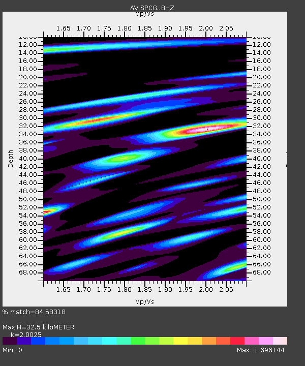
| Estimated Moho Depth: |
32.5 km |
| Estimated Crust Vp/Vs: |
2.00 |
| Assumed Crust Vp: |
6.566 km/s |
| Estimated Crust Vs: |
3.279 km/s |
| Estimated Crust Poisson's Ratio: |
0.33 |
|
| Radial Match: |
84.58318 % |
| Radial Bump: |
400 |
| Transverse Match: |
83.584366 % |
| Transverse Bump: |
399 |
| SOD ConfigId: |
7019011 |
| Insert Time: |
2019-04-16 22:48:00.663 +0000 |
| GWidth: |
2.5 |
| Max Bumps: |
400 |
| Tol: |
0.001 |
|

Signal To Noise
| Channel | StoN | STA | LTA |
| AV:SPCG: :BHZ:20150219T13:30:29.959006Z | 14.0110655 | 2.0168711E-6 | 1.4394845E-7 |
| AV:SPCG: :BHN:20150219T13:30:29.959006Z | 3.5512373 | 6.079583E-7 | 1.7119619E-7 |
| AV:SPCG: :BHE:20150219T13:30:29.959006Z | 2.455865 | 3.695674E-7 | 1.504836E-7 |
| Arrivals |
| Ps | 5.1 SECOND |
| PpPs | 15 SECOND |
| PsPs/PpSs | 20 SECOND |


