You are here: Home > Network List > II - Global Seismograph Network (GSN - IRIS/IDA) Stations List
> Station PFO Pinon Flat, California, USA > Earthquake Result Viewer
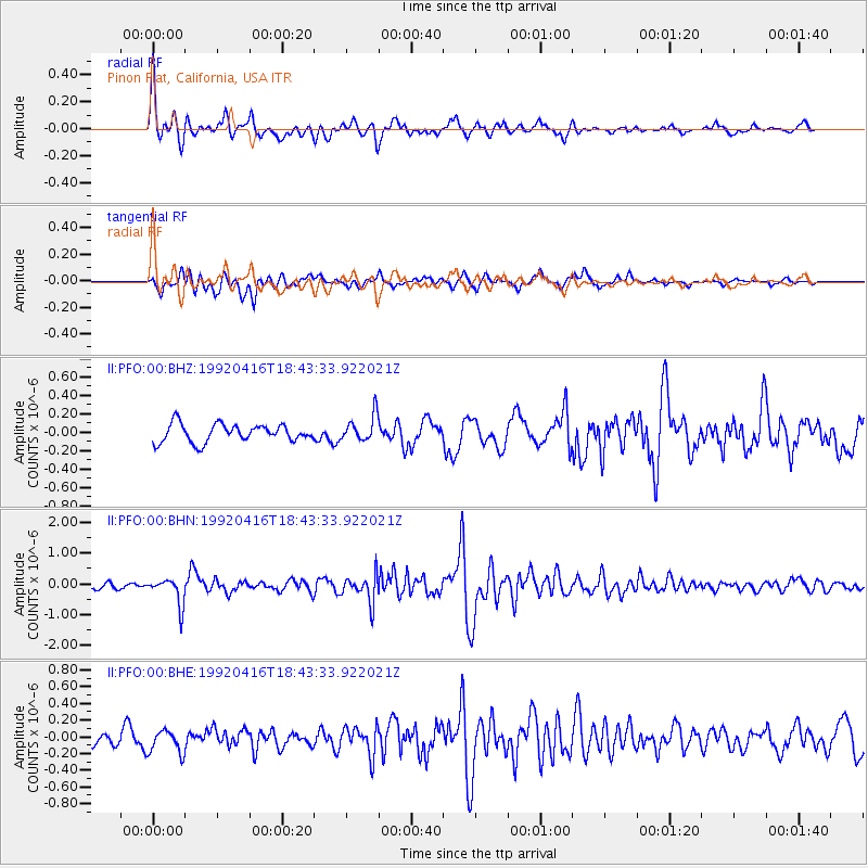
PFO Pinon Flat, California, USA - Earthquake Result Viewer
*The percent match for this event was below the threshold and hence no stack was calculated.
| Earthquake location: |
Chile-Bolivia Border Region |
| Earthquake latitude/longitude: |
-20.1/-68.5 |
| Earthquake time(UTC): |
1992/04/16 (107) 18:33:04 GMT |
| Earthquake Depth: |
122 km |
| Earthquake Magnitude: |
5.6 MB |
| Earthquake Catalog/Contributor: |
WHDF/NEIC |
|
| Network: |
II Global Seismograph Network (GSN - IRIS/IDA) |
| Station: |
PFO Pinon Flat, California, USA |
| Lat/Lon: |
33.61 N/116.46 W |
| Elevation: |
1280 m |
|
| Distance: |
70.3 deg |
| Az: |
318.855 deg |
| Baz: |
132.19 deg |
| Ray Param: |
$rayparam |
*The percent match for this event was below the threshold and hence was not used in the summary stack. |
|
| Radial Match: |
79.29859 % |
| Radial Bump: |
386 |
| Transverse Match: |
67.71205 % |
| Transverse Bump: |
400 |
| SOD ConfigId: |
4480 |
| Insert Time: |
2010-03-01 21:45:45.402 +0000 |
| GWidth: |
2.5 |
| Max Bumps: |
400 |
| Tol: |
0.001 |
|
Signal To Noise
| Channel | StoN | STA | LTA |
| II:PFO:00:BHN:19920416T18:43:33.922021Z | 4.683178 | 4.404607E-7 | 9.405167E-8 |
| II:PFO:00:BHE:19920416T18:43:33.922021Z | 1.5684104 | 1.3856652E-7 | 8.834838E-8 |
| II:PFO:00:BHZ:19920416T18:43:33.922021Z | 1.462186 | 1.4184776E-7 | 9.7010755E-8 |
| Arrivals |
| Ps | |
| PpPs | |
| PsPs/PpSs | |


