You are here: Home > Network List > TA - USArray Transportable Network (new EarthScope stations) Stations List
> Station 109C Camp Elliot, Mirimar, CA, USA > Earthquake Result Viewer
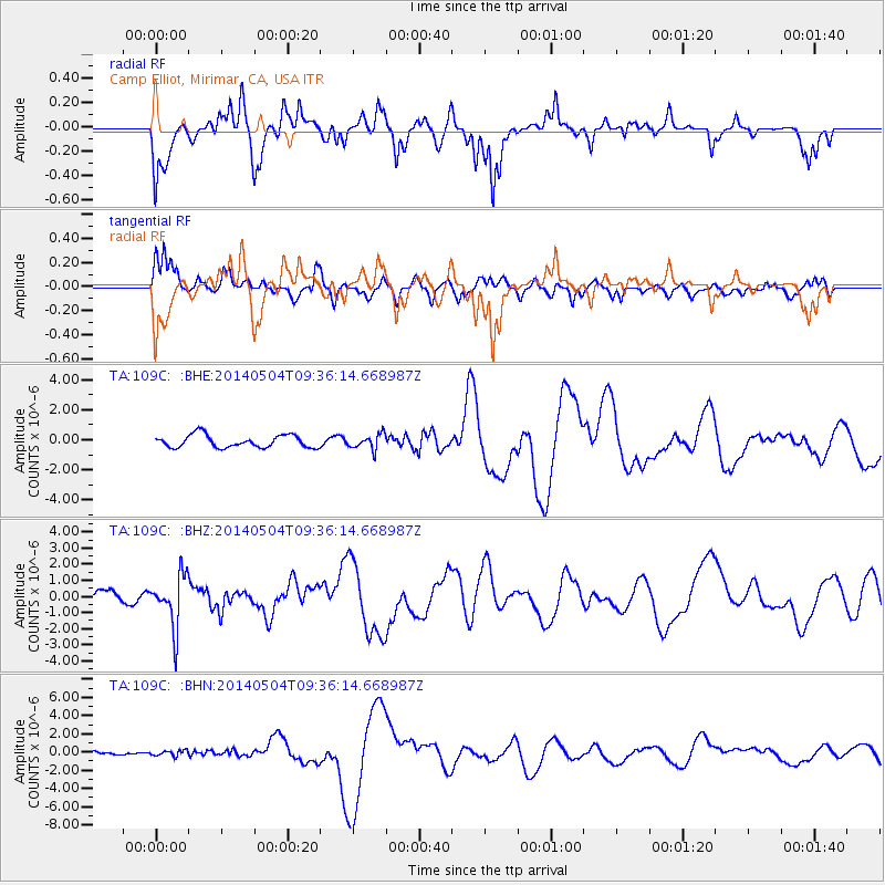
109C Camp Elliot, Mirimar, CA, USA - Earthquake Result Viewer
*The percent match for this event was below the threshold and hence no stack was calculated.
| Earthquake location: |
South Of Fiji Islands |
| Earthquake latitude/longitude: |
-25.8/178.2 |
| Earthquake time(UTC): |
2014/05/04 (124) 09:25:14 GMT |
| Earthquake Depth: |
611 km |
| Earthquake Magnitude: |
6.1 MB |
| Earthquake Catalog/Contributor: |
NEIC PDE/NEIC COMCAT |
|
| Network: |
TA USArray Transportable Network (new EarthScope stations) |
| Station: |
109C Camp Elliot, Mirimar, CA, USA |
| Lat/Lon: |
32.89 N/117.11 W |
| Elevation: |
150 m |
|
| Distance: |
84.8 deg |
| Az: |
49.794 deg |
| Baz: |
234.912 deg |
| Ray Param: |
$rayparam |
*The percent match for this event was below the threshold and hence was not used in the summary stack. |
|
| Radial Match: |
52.40846 % |
| Radial Bump: |
343 |
| Transverse Match: |
52.377968 % |
| Transverse Bump: |
398 |
| SOD ConfigId: |
626651 |
| Insert Time: |
2014-05-18 10:34:28.171 +0000 |
| GWidth: |
2.5 |
| Max Bumps: |
400 |
| Tol: |
0.001 |
|
Signal To Noise
| Channel | StoN | STA | LTA |
| TA:109C: :BHZ:20140504T09:36:14.668987Z | 3.2083783 | 1.6059294E-6 | 5.005424E-7 |
| TA:109C: :BHN:20140504T09:36:14.668987Z | 1.5122061 | 2.9876472E-7 | 1.9756878E-7 |
| TA:109C: :BHE:20140504T09:36:14.668987Z | 1.2029451 | 5.0139084E-7 | 4.1680275E-7 |
| Arrivals |
| Ps | |
| PpPs | |
| PsPs/PpSs | |


