You are here: Home > Network List > TA - USArray Transportable Network (new EarthScope stations) Stations List
> Station 833A Chaparral WMA, Artesia Wells, TX, USA > Earthquake Result Viewer
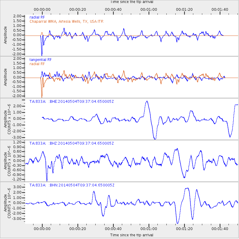
833A Chaparral WMA, Artesia Wells, TX, USA - Earthquake Result Viewer
*The percent match for this event was below the threshold and hence no stack was calculated.
| Earthquake location: |
South Of Fiji Islands |
| Earthquake latitude/longitude: |
-25.8/178.2 |
| Earthquake time(UTC): |
2014/05/04 (124) 09:25:14 GMT |
| Earthquake Depth: |
611 km |
| Earthquake Magnitude: |
6.1 MB |
| Earthquake Catalog/Contributor: |
NEIC PDE/NEIC COMCAT |
|
| Network: |
TA USArray Transportable Network (new EarthScope stations) |
| Station: |
833A Chaparral WMA, Artesia Wells, TX, USA |
| Lat/Lon: |
28.32 N/99.39 W |
| Elevation: |
171 m |
|
| Distance: |
95.7 deg |
| Az: |
61.424 deg |
| Baz: |
243.894 deg |
| Ray Param: |
$rayparam |
*The percent match for this event was below the threshold and hence was not used in the summary stack. |
|
| Radial Match: |
50.914467 % |
| Radial Bump: |
400 |
| Transverse Match: |
56.345444 % |
| Transverse Bump: |
400 |
| SOD ConfigId: |
626651 |
| Insert Time: |
2014-05-18 10:34:40.535 +0000 |
| GWidth: |
2.5 |
| Max Bumps: |
400 |
| Tol: |
0.001 |
|
Signal To Noise
| Channel | StoN | STA | LTA |
| TA:833A: :BHZ:20140504T09:37:04.650005Z | 4.224153 | 5.5595126E-7 | 1.3161247E-7 |
| TA:833A: :BHN:20140504T09:37:04.650005Z | 1.76282 | 2.873419E-7 | 1.6300126E-7 |
| TA:833A: :BHE:20140504T09:37:04.650005Z | 3.1999621 | 5.493255E-7 | 1.7166624E-7 |
| Arrivals |
| Ps | |
| PpPs | |
| PsPs/PpSs | |


