You are here: Home > Network List > TA - USArray Transportable Network (new EarthScope stations) Stations List
> Station G03D McMinnville, OR, USA > Earthquake Result Viewer
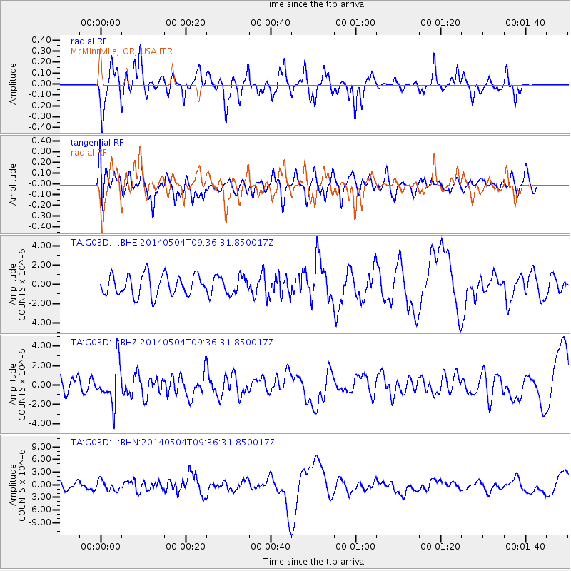
G03D McMinnville, OR, USA - Earthquake Result Viewer
*The percent match for this event was below the threshold and hence no stack was calculated.
| Earthquake location: |
South Of Fiji Islands |
| Earthquake latitude/longitude: |
-25.8/178.2 |
| Earthquake time(UTC): |
2014/05/04 (124) 09:25:14 GMT |
| Earthquake Depth: |
611 km |
| Earthquake Magnitude: |
6.1 MB |
| Earthquake Catalog/Contributor: |
NEIC PDE/NEIC COMCAT |
|
| Network: |
TA USArray Transportable Network (new EarthScope stations) |
| Station: |
G03D McMinnville, OR, USA |
| Lat/Lon: |
45.21 N/123.26 W |
| Elevation: |
222 m |
|
| Distance: |
88.5 deg |
| Az: |
37.092 deg |
| Baz: |
230.276 deg |
| Ray Param: |
$rayparam |
*The percent match for this event was below the threshold and hence was not used in the summary stack. |
|
| Radial Match: |
26.250725 % |
| Radial Bump: |
254 |
| Transverse Match: |
39.42869 % |
| Transverse Bump: |
395 |
| SOD ConfigId: |
626651 |
| Insert Time: |
2014-05-18 10:35:05.420 +0000 |
| GWidth: |
2.5 |
| Max Bumps: |
400 |
| Tol: |
0.001 |
|
Signal To Noise
| Channel | StoN | STA | LTA |
| TA:G03D: :BHZ:20140504T09:36:31.850017Z | 2.7470818 | 2.1180701E-6 | 7.710255E-7 |
| TA:G03D: :BHN:20140504T09:36:31.850017Z | 1.3921541 | 1.2104858E-6 | 8.6950564E-7 |
| TA:G03D: :BHE:20140504T09:36:31.850017Z | 0.81226844 | 8.7574597E-7 | 1.0781484E-6 |
| Arrivals |
| Ps | |
| PpPs | |
| PsPs/PpSs | |


