You are here: Home > Network List > TA - USArray Transportable Network (new EarthScope stations) Stations List
> Station G05D Wamic, OR, USA > Earthquake Result Viewer
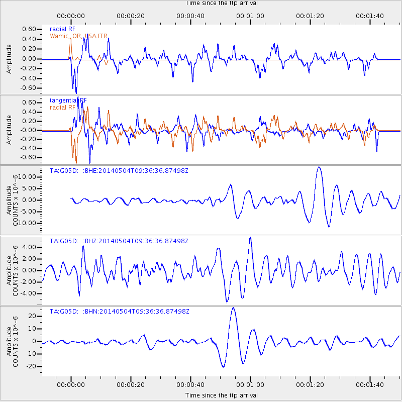
G05D Wamic, OR, USA - Earthquake Result Viewer
*The percent match for this event was below the threshold and hence no stack was calculated.
| Earthquake location: |
South Of Fiji Islands |
| Earthquake latitude/longitude: |
-25.8/178.2 |
| Earthquake time(UTC): |
2014/05/04 (124) 09:25:14 GMT |
| Earthquake Depth: |
611 km |
| Earthquake Magnitude: |
6.1 MB |
| Earthquake Catalog/Contributor: |
NEIC PDE/NEIC COMCAT |
|
| Network: |
TA USArray Transportable Network (new EarthScope stations) |
| Station: |
G05D Wamic, OR, USA |
| Lat/Lon: |
45.24 N/121.32 W |
| Elevation: |
592 m |
|
| Distance: |
89.6 deg |
| Az: |
37.935 deg |
| Baz: |
231.669 deg |
| Ray Param: |
$rayparam |
*The percent match for this event was below the threshold and hence was not used in the summary stack. |
|
| Radial Match: |
35.187073 % |
| Radial Bump: |
240 |
| Transverse Match: |
49.760403 % |
| Transverse Bump: |
300 |
| SOD ConfigId: |
626651 |
| Insert Time: |
2014-05-18 10:35:09.911 +0000 |
| GWidth: |
2.5 |
| Max Bumps: |
400 |
| Tol: |
0.001 |
|
Signal To Noise
| Channel | StoN | STA | LTA |
| TA:G05D: :BHZ:20140504T09:36:36.87498Z | 1.7704777 | 2.0106177E-6 | 1.1356358E-6 |
| TA:G05D: :BHN:20140504T09:36:36.87498Z | 0.49026605 | 5.0069985E-7 | 1.021282E-6 |
| TA:G05D: :BHE:20140504T09:36:36.87498Z | 0.5902817 | 4.9157296E-7 | 8.3277695E-7 |
| Arrivals |
| Ps | |
| PpPs | |
| PsPs/PpSs | |


