You are here: Home > Network List > TA - USArray Transportable Network (new EarthScope stations) Stations List
> Station R11A Troy Canyon, Currant, NV, USA > Earthquake Result Viewer
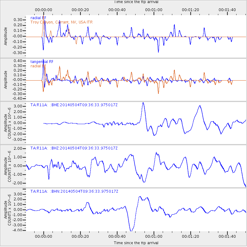
R11A Troy Canyon, Currant, NV, USA - Earthquake Result Viewer
*The percent match for this event was below the threshold and hence no stack was calculated.
| Earthquake location: |
South Of Fiji Islands |
| Earthquake latitude/longitude: |
-25.8/178.2 |
| Earthquake time(UTC): |
2014/05/04 (124) 09:25:14 GMT |
| Earthquake Depth: |
611 km |
| Earthquake Magnitude: |
6.1 MB |
| Earthquake Catalog/Contributor: |
NEIC PDE/NEIC COMCAT |
|
| Network: |
TA USArray Transportable Network (new EarthScope stations) |
| Station: |
R11A Troy Canyon, Currant, NV, USA |
| Lat/Lon: |
38.35 N/115.59 W |
| Elevation: |
1756 m |
|
| Distance: |
88.9 deg |
| Az: |
46.019 deg |
| Baz: |
235.588 deg |
| Ray Param: |
$rayparam |
*The percent match for this event was below the threshold and hence was not used in the summary stack. |
|
| Radial Match: |
19.648994 % |
| Radial Bump: |
200 |
| Transverse Match: |
30.944077 % |
| Transverse Bump: |
400 |
| SOD ConfigId: |
626651 |
| Insert Time: |
2014-05-18 10:36:18.783 +0000 |
| GWidth: |
2.5 |
| Max Bumps: |
400 |
| Tol: |
0.001 |
|
Signal To Noise
| Channel | StoN | STA | LTA |
| TA:R11A: :BHZ:20140504T09:36:33.975017Z | 2.650331 | 5.298323E-7 | 1.9991174E-7 |
| TA:R11A: :BHN:20140504T09:36:33.975017Z | 1.8405087 | 2.3927942E-7 | 1.3000722E-7 |
| TA:R11A: :BHE:20140504T09:36:33.975017Z | 2.531301 | 2.2485285E-7 | 8.882896E-8 |
| Arrivals |
| Ps | |
| PpPs | |
| PsPs/PpSs | |


