You are here: Home > Network List > TA - USArray Transportable Network (new EarthScope stations) Stations List
> Station T25A Trinidad, CO, USA > Earthquake Result Viewer
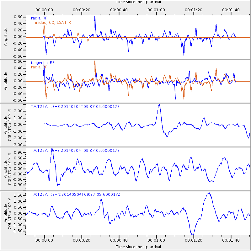
T25A Trinidad, CO, USA - Earthquake Result Viewer
*The percent match for this event was below the threshold and hence no stack was calculated.
| Earthquake location: |
South Of Fiji Islands |
| Earthquake latitude/longitude: |
-25.8/178.2 |
| Earthquake time(UTC): |
2014/05/04 (124) 09:25:14 GMT |
| Earthquake Depth: |
611 km |
| Earthquake Magnitude: |
6.1 MB |
| Earthquake Catalog/Contributor: |
NEIC PDE/NEIC COMCAT |
|
| Network: |
TA USArray Transportable Network (new EarthScope stations) |
| Station: |
T25A Trinidad, CO, USA |
| Lat/Lon: |
37.14 N/104.41 W |
| Elevation: |
2017 m |
|
| Distance: |
95.9 deg |
| Az: |
51.626 deg |
| Baz: |
242.177 deg |
| Ray Param: |
$rayparam |
*The percent match for this event was below the threshold and hence was not used in the summary stack. |
|
| Radial Match: |
42.58418 % |
| Radial Bump: |
319 |
| Transverse Match: |
50.56652 % |
| Transverse Bump: |
400 |
| SOD ConfigId: |
626651 |
| Insert Time: |
2014-05-18 10:36:25.377 +0000 |
| GWidth: |
2.5 |
| Max Bumps: |
400 |
| Tol: |
0.001 |
|
Signal To Noise
| Channel | StoN | STA | LTA |
| TA:T25A: :BHZ:20140504T09:37:05.600017Z | 3.106539 | 5.4811335E-7 | 1.7643858E-7 |
| TA:T25A: :BHN:20140504T09:37:05.600017Z | 3.5408275 | 3.0594174E-7 | 8.640402E-8 |
| TA:T25A: :BHE:20140504T09:37:05.600017Z | 2.0257416 | 2.7297813E-7 | 1.3475466E-7 |
| Arrivals |
| Ps | |
| PpPs | |
| PsPs/PpSs | |


