You are here: Home > Network List > CI - Caltech Regional Seismic Network Stations List
> Station SHO Shoshone, CA, USA > Earthquake Result Viewer
SHO Shoshone, CA, USA - Earthquake Result Viewer

| Earthquake location: |
Vanuatu Islands |
| Earthquake latitude/longitude: |
-16.4/168.1 |
| Earthquake time(UTC): |
2015/02/19 (050) 13:18:32 GMT |
| Earthquake Depth: |
10 km |
| Earthquake Magnitude: |
6.5 MWP |
| Earthquake Catalog/Contributor: |
NEIC PDE/NEIC COMCAT |
|
| Network: |
CI Caltech Regional Seismic Network |
| Station: |
SHO Shoshone, CA, USA |
| Lat/Lon: |
35.90 N/116.28 W |
| Elevation: |
451 m |
|
| Distance: |
88.3 deg |
| Az: |
51.894 deg |
| Baz: |
248.47 deg |
| Ray Param: |
0.042682532 |
| Estimated Moho Depth: |
29.5 km |
| Estimated Crust Vp/Vs: |
1.70 |
| Assumed Crust Vp: |
6.276 km/s |
| Estimated Crust Vs: |
3.703 km/s |
| Estimated Crust Poisson's Ratio: |
0.23 |
|
| Radial Match: |
87.86447 % |
| Radial Bump: |
400 |
| Transverse Match: |
82.31347 % |
| Transverse Bump: |
400 |
| SOD ConfigId: |
7019011 |
| Insert Time: |
2019-04-16 22:49:39.373 +0000 |
| GWidth: |
2.5 |
| Max Bumps: |
400 |
| Tol: |
0.001 |
|
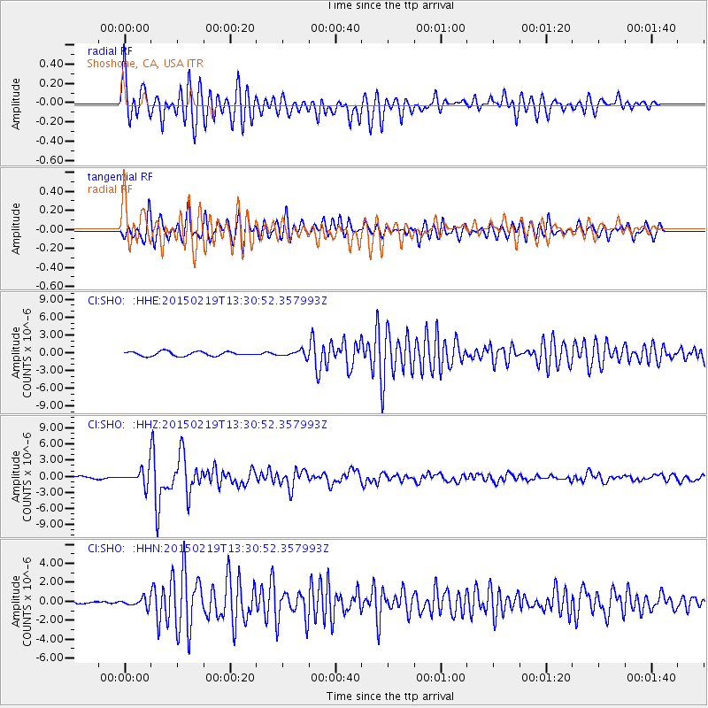
Signal To Noise
| Channel | StoN | STA | LTA |
| CI:SHO: :HHZ:20150219T13:30:52.357993Z | 7.5100913 | 1.5656908E-6 | 2.0847826E-7 |
| CI:SHO: :HHN:20150219T13:30:52.357993Z | 1.8862938 | 4.3051386E-7 | 2.2823268E-7 |
| CI:SHO: :HHE:20150219T13:30:52.357993Z | 1.453037 | 5.3282736E-7 | 3.6669908E-7 |
| Arrivals |
| Ps | 3.3 SECOND |
| PpPs | 12 SECOND |
| PsPs/PpSs | 16 SECOND |


