You are here: Home > Network List > CI - Caltech Regional Seismic Network Stations List
> Station SWS Sam W. Stewart, Westmorland, CA, USA > Earthquake Result Viewer
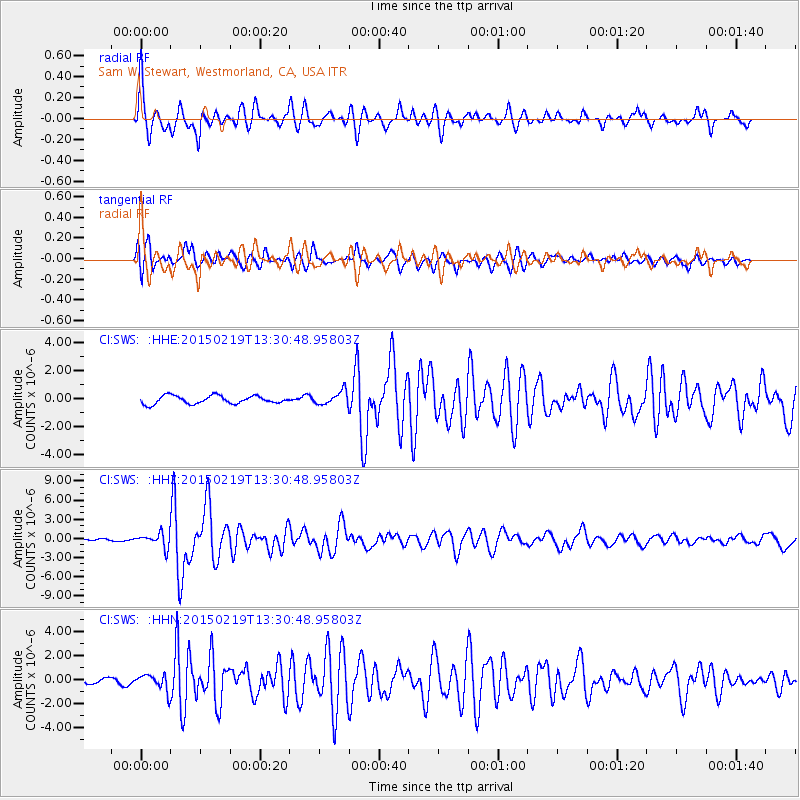
SWS Sam W. Stewart, Westmorland, CA, USA - Earthquake Result Viewer

| Earthquake location: |
Vanuatu Islands |
| Earthquake latitude/longitude: |
-16.4/168.1 |
| Earthquake time(UTC): |
2015/02/19 (050) 13:18:32 GMT |
| Earthquake Depth: |
10 km |
| Earthquake Magnitude: |
6.5 MWP |
| Earthquake Catalog/Contributor: |
NEIC PDE/NEIC COMCAT |
|
| Network: |
CI Caltech Regional Seismic Network |
| Station: |
SWS Sam W. Stewart, Westmorland, CA, USA |
| Lat/Lon: |
32.94 N/115.80 W |
| Elevation: |
140 m |
|
| Distance: |
87.6 deg |
| Az: |
54.79 deg |
| Baz: |
248.843 deg |
| Ray Param: |
0.04320669 |
| Estimated Moho Depth: |
40.5 km |
| Estimated Crust Vp/Vs: |
2.05 |
| Assumed Crust Vp: |
6.155 km/s |
| Estimated Crust Vs: |
3.006 km/s |
| Estimated Crust Poisson's Ratio: |
0.34 |
|
| Radial Match: |
88.23723 % |
| Radial Bump: |
400 |
| Transverse Match: |
87.161804 % |
| Transverse Bump: |
400 |
| SOD ConfigId: |
7019011 |
| Insert Time: |
2019-04-16 22:49:44.754 +0000 |
| GWidth: |
2.5 |
| Max Bumps: |
400 |
| Tol: |
0.001 |
|
Signal To Noise
| Channel | StoN | STA | LTA |
| CI:SWS: :HHZ:20150219T13:30:48.95803Z | 6.6530437 | 1.0993797E-6 | 1.6524463E-7 |
| CI:SWS: :HHN:20150219T13:30:48.95803Z | 1.8429726 | 6.927501E-7 | 3.7588737E-7 |
| CI:SWS: :HHE:20150219T13:30:48.95803Z | 1.8471391 | 5.2757997E-7 | 2.8562005E-7 |
| Arrivals |
| Ps | 7.0 SECOND |
| PpPs | 20 SECOND |
| PsPs/PpSs | 27 SECOND |


