You are here: Home > Network List > UW - Pacific Northwest Regional Seismic Network Stations List
> Station LEBA Lebam, WA, USA > Earthquake Result Viewer
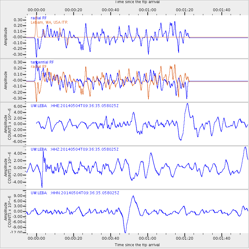
LEBA Lebam, WA, USA - Earthquake Result Viewer
*The percent match for this event was below the threshold and hence no stack was calculated.
| Earthquake location: |
South Of Fiji Islands |
| Earthquake latitude/longitude: |
-25.8/178.2 |
| Earthquake time(UTC): |
2014/05/04 (124) 09:25:14 GMT |
| Earthquake Depth: |
611 km |
| Earthquake Magnitude: |
6.1 MB |
| Earthquake Catalog/Contributor: |
NEIC PDE/NEIC COMCAT |
|
| Network: |
UW Pacific Northwest Regional Seismic Network |
| Station: |
LEBA Lebam, WA, USA |
| Lat/Lon: |
46.55 N/123.56 W |
| Elevation: |
73 m |
|
| Distance: |
89.2 deg |
| Az: |
35.933 deg |
| Baz: |
230.039 deg |
| Ray Param: |
$rayparam |
*The percent match for this event was below the threshold and hence was not used in the summary stack. |
|
| Radial Match: |
26.833622 % |
| Radial Bump: |
400 |
| Transverse Match: |
33.757008 % |
| Transverse Bump: |
400 |
| SOD ConfigId: |
626651 |
| Insert Time: |
2014-05-18 10:40:19.038 +0000 |
| GWidth: |
2.5 |
| Max Bumps: |
400 |
| Tol: |
0.001 |
|
Signal To Noise
| Channel | StoN | STA | LTA |
| UW:LEBA: :HHZ:20140504T09:36:35.058025Z | 3.4783542 | 2.2572833E-6 | 6.489515E-7 |
| UW:LEBA: :HHN:20140504T09:36:35.058025Z | 0.98708665 | 1.0437117E-6 | 1.0573658E-6 |
| UW:LEBA: :HHE:20140504T09:36:35.058025Z | 0.54587686 | 5.919649E-7 | 1.0844294E-6 |
| Arrivals |
| Ps | |
| PpPs | |
| PsPs/PpSs | |


