You are here: Home > Network List > NN - Western Great Basin/Eastern Sierra Nevada Stations List
> Station PAH Pah Rah Range, Nevada w84gm > Earthquake Result Viewer
PAH Pah Rah Range, Nevada w84gm - Earthquake Result Viewer
| Earthquake location: |
Vanuatu Islands |
| Earthquake latitude/longitude: |
-16.4/168.1 |
| Earthquake time(UTC): |
2015/02/19 (050) 13:18:32 GMT |
| Earthquake Depth: |
10 km |
| Earthquake Magnitude: |
6.5 MWP |
| Earthquake Catalog/Contributor: |
NEIC PDE/NEIC COMCAT |
|
| Network: |
NN Western Great Basin/Eastern Sierra Nevada |
| Station: |
PAH Pah Rah Range, Nevada w84gm |
| Lat/Lon: |
39.71 N/119.39 W |
| Elevation: |
1520 m |
|
| Distance: |
87.5 deg |
| Az: |
47.434 deg |
| Baz: |
246.407 deg |
| Ray Param: |
0.043287173 |
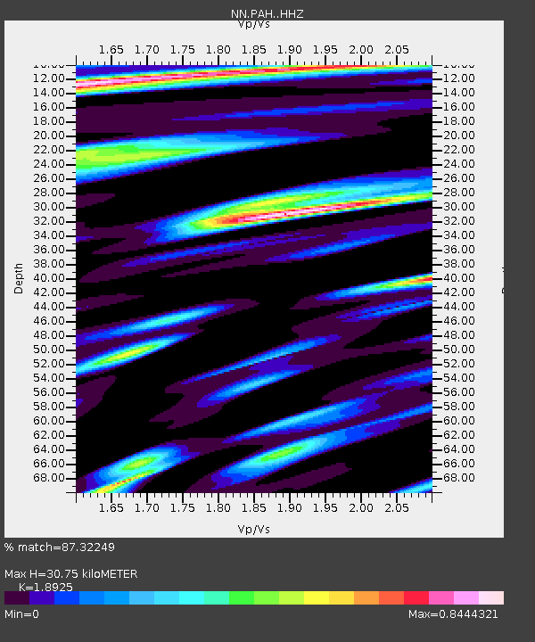
| Estimated Moho Depth: |
30.75 km |
| Estimated Crust Vp/Vs: |
1.89 |
| Assumed Crust Vp: |
6.279 km/s |
| Estimated Crust Vs: |
3.318 km/s |
| Estimated Crust Poisson's Ratio: |
0.31 |
|
| Radial Match: |
87.32249 % |
| Radial Bump: |
400 |
| Transverse Match: |
83.602234 % |
| Transverse Bump: |
400 |
| SOD ConfigId: |
7019011 |
| Insert Time: |
2019-04-16 22:50:59.582 +0000 |
| GWidth: |
2.5 |
| Max Bumps: |
400 |
| Tol: |
0.001 |
|

Signal To Noise
| Channel | StoN | STA | LTA |
| NN:PAH: :HHZ:20150219T13:30:48.495017Z | 5.489618 | 1.5989662E-6 | 2.9127094E-7 |
| NN:PAH: :HHN:20150219T13:30:48.495017Z | 0.7174855 | 2.2774653E-7 | 3.174232E-7 |
| NN:PAH: :HHE:20150219T13:30:48.495017Z | 1.9293308 | 3.5852136E-7 | 1.8582679E-7 |
| Arrivals |
| Ps | 4.5 SECOND |
| PpPs | 14 SECOND |
| PsPs/PpSs | 18 SECOND |


