You are here: Home > Network List > PS - Pacific21 Stations List
> Station PSI Parapat, Indonesia > Earthquake Result Viewer
PSI Parapat, Indonesia - Earthquake Result Viewer
| Earthquake location: |
Vanuatu Islands |
| Earthquake latitude/longitude: |
-16.4/168.1 |
| Earthquake time(UTC): |
2015/02/19 (050) 13:18:32 GMT |
| Earthquake Depth: |
10 km |
| Earthquake Magnitude: |
6.5 MWP |
| Earthquake Catalog/Contributor: |
NEIC PDE/NEIC COMCAT |
|
| Network: |
PS Pacific21 |
| Station: |
PSI Parapat, Indonesia |
| Lat/Lon: |
2.69 N/98.92 E |
| Elevation: |
987 m |
|
| Distance: |
70.9 deg |
| Az: |
278.799 deg |
| Baz: |
108.275 deg |
| Ray Param: |
0.05470496 |
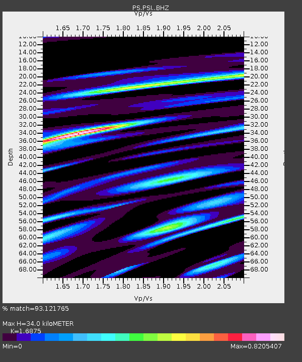
| Estimated Moho Depth: |
34.0 km |
| Estimated Crust Vp/Vs: |
1.69 |
| Assumed Crust Vp: |
6.468 km/s |
| Estimated Crust Vs: |
3.833 km/s |
| Estimated Crust Poisson's Ratio: |
0.23 |
|
| Radial Match: |
93.121765 % |
| Radial Bump: |
400 |
| Transverse Match: |
86.228 % |
| Transverse Bump: |
400 |
| SOD ConfigId: |
7019011 |
| Insert Time: |
2019-04-16 22:51:29.136 +0000 |
| GWidth: |
2.5 |
| Max Bumps: |
400 |
| Tol: |
0.001 |
|
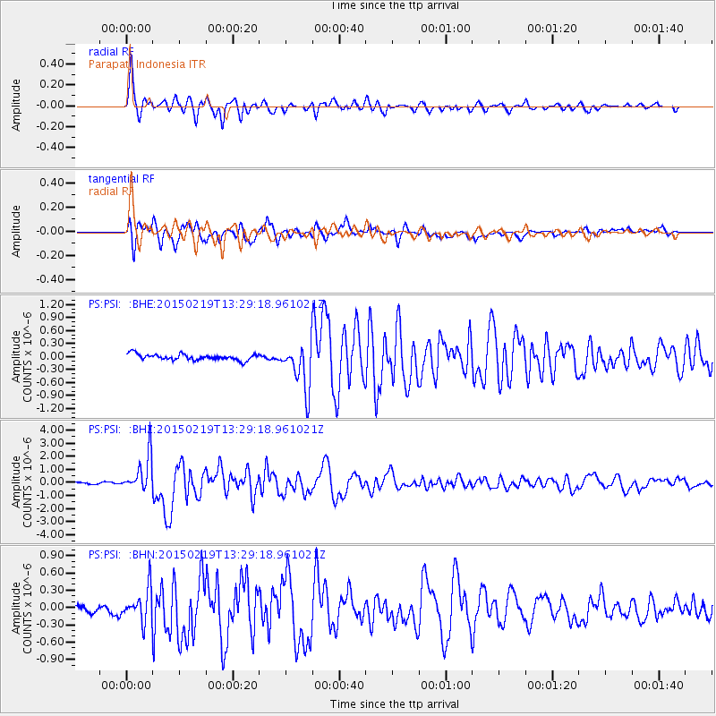
Signal To Noise
| Channel | StoN | STA | LTA |
| PS:PSI: :BHZ:20150219T13:29:18.961021Z | 16.181744 | 1.4076975E-6 | 8.699294E-8 |
| PS:PSI: :BHN:20150219T13:29:18.961021Z | 1.8533375 | 2.9452465E-7 | 1.5891582E-7 |
| PS:PSI: :BHE:20150219T13:29:18.961021Z | 6.749962 | 4.7167208E-7 | 6.987774E-8 |
| Arrivals |
| Ps | 3.8 SECOND |
| PpPs | 14 SECOND |
| PsPs/PpSs | 17 SECOND |


