You are here: Home > Network List > TA - USArray Transportable Network (new EarthScope stations) Stations List
> Station J04D Umpqua National Forest, Toketee, OR, USA > Earthquake Result Viewer
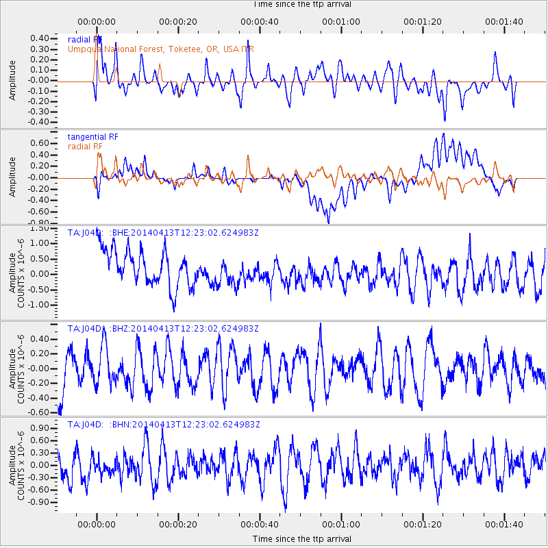
J04D Umpqua National Forest, Toketee, OR, USA - Earthquake Result Viewer
*The percent match for this event was below the threshold and hence no stack was calculated.
| Earthquake location: |
Near Coast Of Northern Chile |
| Earthquake latitude/longitude: |
-20.6/-70.7 |
| Earthquake time(UTC): |
2014/04/13 (103) 12:11:30 GMT |
| Earthquake Depth: |
13 km |
| Earthquake Magnitude: |
5.5 MWW, 5.3 MWR |
| Earthquake Catalog/Contributor: |
NEIC PDE/NEIC COMCAT |
|
| Network: |
TA USArray Transportable Network (new EarthScope stations) |
| Station: |
J04D Umpqua National Forest, Toketee, OR, USA |
| Lat/Lon: |
43.24 N/122.11 W |
| Elevation: |
1948 m |
|
| Distance: |
79.1 deg |
| Az: |
324.457 deg |
| Baz: |
131.808 deg |
| Ray Param: |
$rayparam |
*The percent match for this event was below the threshold and hence was not used in the summary stack. |
|
| Radial Match: |
53.312897 % |
| Radial Bump: |
400 |
| Transverse Match: |
45.770454 % |
| Transverse Bump: |
400 |
| SOD ConfigId: |
626651 |
| Insert Time: |
2014-05-18 10:59:58.372 +0000 |
| GWidth: |
2.5 |
| Max Bumps: |
400 |
| Tol: |
0.001 |
|
Signal To Noise
| Channel | StoN | STA | LTA |
| TA:J04D: :BHZ:20140413T12:23:02.624983Z | 0.9592571 | 2.7045866E-7 | 2.8194594E-7 |
| TA:J04D: :BHN:20140413T12:23:02.624983Z | 0.61662656 | 2.859868E-7 | 4.6379256E-7 |
| TA:J04D: :BHE:20140413T12:23:02.624983Z | 0.8450123 | 4.8487993E-7 | 5.738141E-7 |
| Arrivals |
| Ps | |
| PpPs | |
| PsPs/PpSs | |


