You are here: Home > Network List > S - Seismographs in Schools Projects Stations List
> Station AUTAR Taroona High School, Taroona, TAS > Earthquake Result Viewer
AUTAR Taroona High School, Taroona, TAS - Earthquake Result Viewer
| Earthquake location: |
Vanuatu Islands |
| Earthquake latitude/longitude: |
-16.4/168.1 |
| Earthquake time(UTC): |
2015/02/19 (050) 13:18:32 GMT |
| Earthquake Depth: |
10 km |
| Earthquake Magnitude: |
6.5 MWP |
| Earthquake Catalog/Contributor: |
NEIC PDE/NEIC COMCAT |
|
| Network: |
S Seismographs in Schools Projects |
| Station: |
AUTAR Taroona High School, Taroona, TAS |
| Lat/Lon: |
42.94 S/147.36 E |
| Elevation: |
25 m |
|
| Distance: |
31.8 deg |
| Az: |
209.535 deg |
| Baz: |
40.116 deg |
| Ray Param: |
0.07891164 |
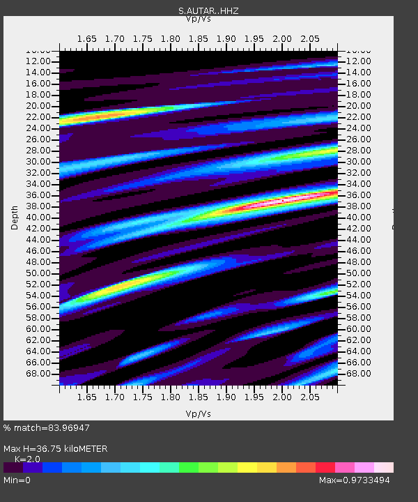
| Estimated Moho Depth: |
36.75 km |
| Estimated Crust Vp/Vs: |
2.00 |
| Assumed Crust Vp: |
6.477 km/s |
| Estimated Crust Vs: |
3.238 km/s |
| Estimated Crust Poisson's Ratio: |
0.33 |
|
| Radial Match: |
83.96947 % |
| Radial Bump: |
400 |
| Transverse Match: |
62.967163 % |
| Transverse Bump: |
400 |
| SOD ConfigId: |
7019011 |
| Insert Time: |
2019-04-16 22:51:51.937 +0000 |
| GWidth: |
2.5 |
| Max Bumps: |
400 |
| Tol: |
0.001 |
|

Signal To Noise
| Channel | StoN | STA | LTA |
| S:AUTAR: :HHZ:20150219T13:24:26.899985Z | 2.3757496 | 2.125662E-6 | 8.9473315E-7 |
| S:AUTAR: :HHN:20150219T13:24:26.899985Z | 1.3054489 | 1.234255E-6 | 9.4546414E-7 |
| S:AUTAR: :HHE:20150219T13:24:26.899985Z | 0.7640976 | 7.377974E-7 | 9.6558E-7 |
| Arrivals |
| Ps | 6.1 SECOND |
| PpPs | 16 SECOND |
| PsPs/PpSs | 22 SECOND |


