You are here: Home > Network List > II - Global Seismograph Network (GSN - IRIS/IDA) Stations List
> Station PFO Pinon Flat, California, USA > Earthquake Result Viewer
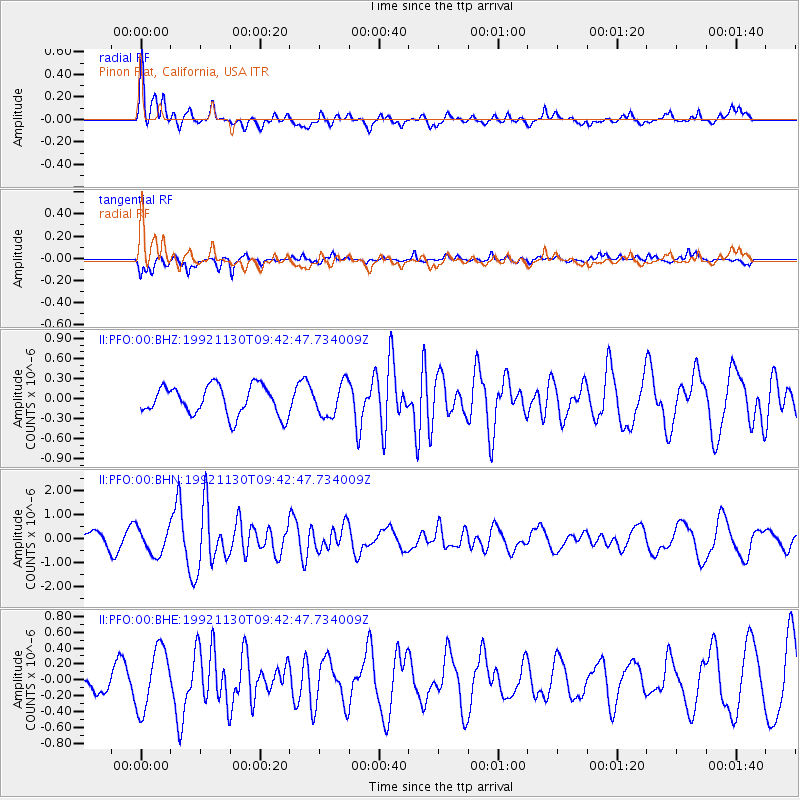
PFO Pinon Flat, California, USA - Earthquake Result Viewer
*The percent match for this event was below the threshold and hence no stack was calculated.
| Earthquake location: |
Azores Islands Region |
| Earthquake latitude/longitude: |
35.6/-34.6 |
| Earthquake time(UTC): |
1992/11/30 (335) 09:32:36 GMT |
| Earthquake Depth: |
10 km |
| Earthquake Magnitude: |
6.0 MB, 5.7 MS |
| Earthquake Catalog/Contributor: |
WHDF/NEIC |
|
| Network: |
II Global Seismograph Network (GSN - IRIS/IDA) |
| Station: |
PFO Pinon Flat, California, USA |
| Lat/Lon: |
33.61 N/116.46 W |
| Elevation: |
1280 m |
|
| Distance: |
65.4 deg |
| Az: |
294.72 deg |
| Baz: |
62.443 deg |
| Ray Param: |
$rayparam |
*The percent match for this event was below the threshold and hence was not used in the summary stack. |
|
| Radial Match: |
72.42268 % |
| Radial Bump: |
400 |
| Transverse Match: |
69.12197 % |
| Transverse Bump: |
330 |
| SOD ConfigId: |
4480 |
| Insert Time: |
2010-03-01 21:46:42.350 +0000 |
| GWidth: |
2.5 |
| Max Bumps: |
400 |
| Tol: |
0.001 |
|
Signal To Noise
| Channel | StoN | STA | LTA |
| II:PFO:00:BHN:19921130T09:42:47.734009Z | 2.4264417 | 5.495604E-7 | 2.2648821E-7 |
| II:PFO:00:BHE:19921130T09:42:47.734009Z | 2.0624456 | 3.890101E-7 | 1.8861591E-7 |
| II:PFO:00:BHZ:19921130T09:42:47.734009Z | 1.1080021 | 2.4207384E-7 | 2.1847778E-7 |
| Arrivals |
| Ps | |
| PpPs | |
| PsPs/PpSs | |


